- Created: August 28, 2012 11:32 am
- Updated: October 6, 2025 8:57 am
- Distance Instructions
- Distance 272 km
- Time 0 s
- Speed 0.0 km/h
- Min altitude 7 m
- Peak 356 m
- Climb 3713 m
- Descent 3713 m
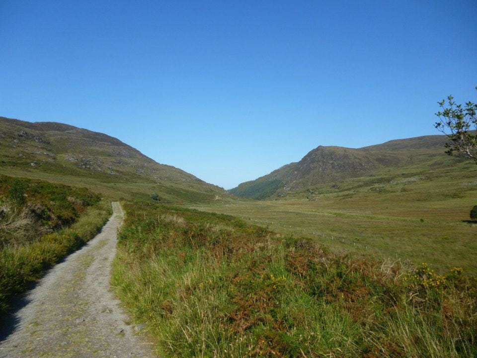
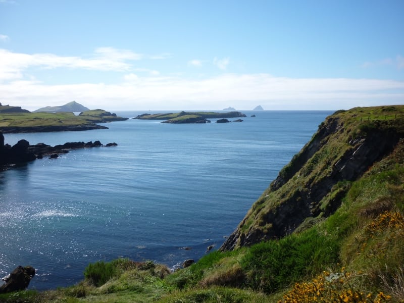
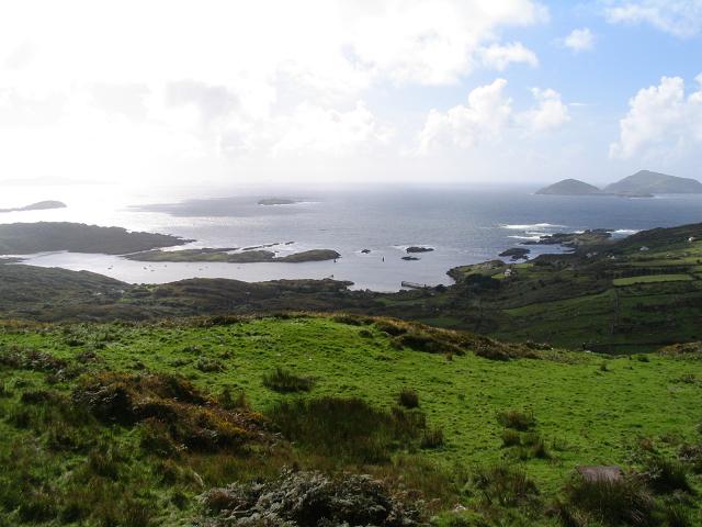
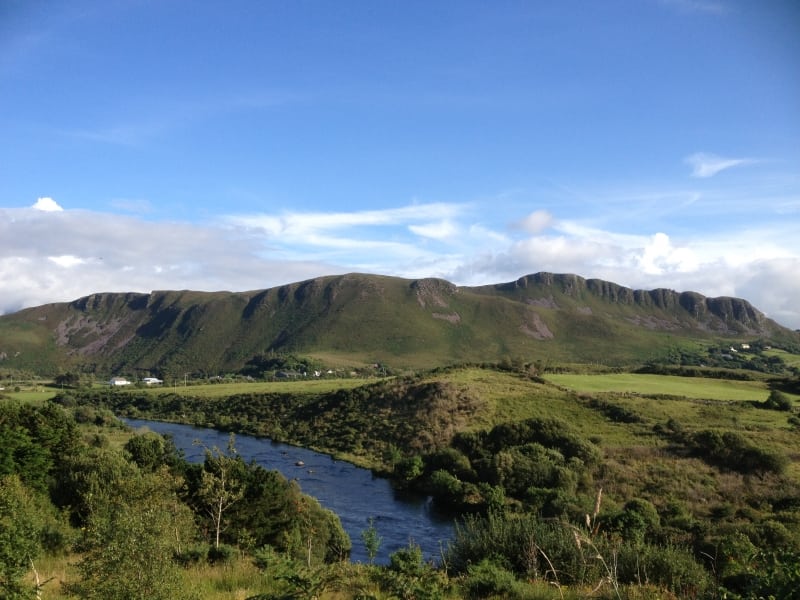
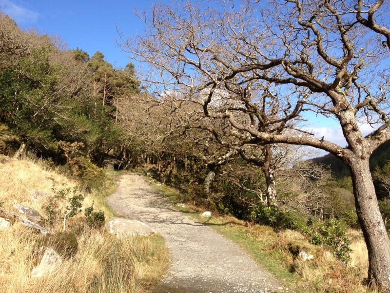
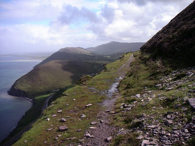
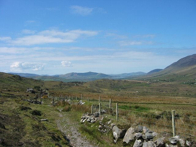
The Kerry Way is an amazingly scenic long distance walking trail in County Kerry, Ireland and is one of the best walking routes in Ireland if not Europe or even I dare say, the World. It is the longest of Irelands National Waymarked Trails at approximately 215 km (134 miles) long and takes between 6 to 12 days to complete in full. The walking route officially begins and ends in Killarney but you can join the trail at any number of points along its length as it hugs the coast along the Wild Atlantic Way. The Kerry Way takes in the entire Iveragh Peninsula, traditionally in an anti clockwise loop and is the walking alternative to the world famous Ring of Kerry scenic drive or cycle which follows a similar route nearby. Take this scenic walking route with you on our free ActiveMe App for iPhone and Android and share your photos on the ActiveMe facebook page. Please note ***Dogs are not permitted on the Kerry Way***

- Local Walking Guide or Tour Guide: coming Soon
- Places to Stay near each stage: see below
- Places for Food Nearby: see below
- Places for Entertainment Nearby: see below
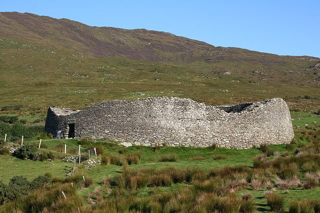
The main towns, villages and key areas on the route include Killarney, Torc and Old Kenmare Road, Black Valley, Bridia Valley, Glencar, Glenbeigh, Mountain Stage, Cahersiveen, Lough Currane, Waterville, Derrynane, Caherdaniel, Eagles Hill, Staigue Fort, Sneem, Blackwater Bridge, Templenoe and Kenmare including many interesting, scenic and colourful places near the route such as Valentia Island. There are also many short loop walks and many mountain hikes and trails off the main Kerry Way Walk offering excellent walking alternatives to cater for all interests.
It is the most popular signposted loop trails in Ireland and one of the worlds most spectacular and diverse walks taking 7 to 10 days to complete, crossing varied and spectacular terrain with overnight stops camping in this wild terrain or in the great towns and villages on the world famous Ring of Kerry. The Iveragh Peninsula much like the neighbouring Dingle Peninsula can be enjoyed on foot via the Dingle Way and by car and bike via the Dingle and Slea Head scenic coastal driving and cycling route along the Wild Atlantic Way. The Kerry Way and the Ring of Kerry is full of picturesque seaside towns and fishing villages, rich in History, Heritage, Irish Mythology and legend, archaeological sites, beaches and many many tourist attractions. The Kerry Way is one of the most popular signposted hiking trails in Ireland and one of the worlds most spectacular and diverse walks.
Typically the entire route is broken down into 9 key stages of approximate equal length or duration. We have also broken some of these longer stages into smaller part to allow everyone irrespective of fitness or time available to experience one of the best and varied walks in Ireland.
Typically the entire Kerry Way route is broken down into 9 key stages of approximate equal length and estimated duration between places with accommodation options. ActiveMe have also broken some of these longer stages into smaller informal sections to allow everyone irrespective of fitness or time available to experience one of the best and varied walks in Ireland. Use our online maps, Apps and elevation profiles to gauge the climb and duration on each stage. Plan your holiday including accommodation using the the various Kerry Way walking trail stages below and don't worry is you want to break these stages into 2 or 3 parts:
- Kerry Way Stage 1 - Killarney to Black Valley - 22km (5 hours)
- Kerry Way Stage 2 - Black Valley to Glencar - 23km (6-7hrs)
- Kerry Way Stage 2 - Part 1 - Black Valley to Bridia Valley - 10km (2-3hrs)
- Kerry Way Stage 2 - Part 2 - Bridia Valley to Glencar - 11km (2-3hrs)
- Kerry Way Stage 3 - Glencar to Glenbeigh - 18km (4hrs)
- Kerry Way Stage 4 - Glenbeigh to Cahersiveen - 28km (5-7hrs)
- Kerry Way Stage 5 - Cahersiveen to Waterville - 29km (5-7hrs)
- Kerry Way Stage 6 - Waterville to Caherdaniel - Coastal Route Option - 13km (2-3 hrs)
- Kerry Way Stage 6 - Waterville to Caherdaniel - Inland Lough Currane Route Option - 29km (5-7 hrs)
- Kerry Way Stage 7 - Caherdaniel to Sneem - 18km (4 hrs)
- Kerry Way Stage 8 - Sneem to Kenmare - 30km (5-7hrs)
- Kerry Way Stage 9 - Kenmare to Killarney on Old Kenmare Road - 24km (4-6hrs)
Accommodation along the Kerry Way Walking Trail (coming soon)
- Killarney
- Black Valley
- Bridia Valley
- Glencar
- Glenbeigh
- Cahersiveen
- Waterville
- Caherdaniel
- Sneem
- Kenmare
Places to Eat along the Kerry Way (coming soon)
- Killarney
- Black Valley
- Bridia Valley
- Glencar
- Glenbeigh
- Cahersiveen
- Waterville
- Caherdaniel
- Sneem
- Kenmare
Use our Map of Ireland and Sat Nav tool to get directions to any of the stage start points and our detailed maps and GPS on our ActiveME App to find and follow the walking route live on screen and keep on track. At all times, our maps and Apps should only be used in conjunction proper map and compass navigation techniques. Feel free to send us your photos and add you own star rating, comments or suggestions below. Take this scenic walking route with you on our free App for iPhone and Android and share your photos on the ActiveMe facebook page.
Plan your walk by checking the weather, sunrise sunset times and our hiking checklist on our website https://www.activeme.ie/useful-info/planning-a-trip/. Please remember that you are only as fast as the slowest member of your group! If the weather is poor don't be afraid to cancel your walk, do some other walk or just wear suitable clothing. This waymarked walk is through remote areas and I would suggest good waterproof boots as some areas can be a little boggy.
With the MacGillycuddy's Reeks and other mountain ranges extending along the north and south of the peninsula, there are also some great mountain hikes and Loop Walks along the Kerry Way route which allow you to explore the local area if you are staying longer. There are great overnight accommodation options and places to eat in the picturesque towns and villages all along the route, making your journey that much better. Luggage transfer and packed lunch services are also available from many of the accommodation and tour providers.
Gallery
The Kerry Way is an amazingly scenic long distance walking trail in County Kerry, Ireland and is one of the best walking routes in Ireland if not Europe or even I dare say, the World. It is the longest of Irelands National Waymarked Trails at approximately 215 km (134 miles) long and takes between 6 to 12 days to complete in full. The walking route officially begins and ends in Killarney but you can join the trail at any number of points along its length as it hugs the coast along the Wild Atlantic Way. The Kerry Way takes in the entire Iveragh Peninsula, traditionally in an anti clockwise loop and is the walking alternative to the world famous Ring of Kerry scenic drive or cycle which follows a similar route nearby. Take this scenic walking route with you on our free ActiveMe App for iPhone and Android and share your photos on the ActiveMe facebook page. Please note ***Dogs are not permitted on the Kerry Way***
- Local Walking Guide or Tour Guide: coming Soon
- Places to Stay near each stage: see below
- Places for Food Nearby: see below
- Places for Entertainment Nearby: see below
The main towns, villages and key areas on the route include Killarney, Torc and Old Kenmare Road, Black Valley, Bridia Valley, Glencar, Glenbeigh, Mountain Stage, Cahersiveen, Lough Currane, Waterville, Derrynane, Caherdaniel, Eagles Hill, Staigue Fort, Sneem, Blackwater Bridge, Templenoe and Kenmare including many interesting, scenic and colourful places near the route such as Valentia Island. There are also many short loop walks and many mountain hikes and trails off the main Kerry Way Walk offering excellent walking alternatives to cater for all interests.
It is the most popular signposted loop trails in Ireland and one of the worlds most spectacular and diverse walks taking 7 to 10 days to complete, crossing varied and spectacular terrain with overnight stops camping in this wild terrain or in the great towns and villages on the world famous Ring of Kerry. The Iveragh Peninsula much like the neighbouring Dingle Peninsula can be enjoyed on foot via the Dingle Way and by car and bike via the Dingle and Slea Head scenic coastal driving and cycling route along the Wild Atlantic Way. The Kerry Way and the Ring of Kerry is full of picturesque seaside towns and fishing villages, rich in History, Heritage, Irish Mythology and legend, archaeological sites, beaches and many many tourist attractions. The Kerry Way is one of the most popular signposted hiking trails in Ireland and one of the worlds most spectacular and diverse walks.
Typically the entire route is broken down into 9 key stages of approximate equal length or duration. We have also broken some of these longer stages into smaller part to allow everyone irrespective of fitness or time available to experience one of the best and varied walks in Ireland.
Typically the entire Kerry Way route is broken down into 9 key stages of approximate equal length and estimated duration between places with accommodation options. ActiveMe have also broken some of these longer stages into smaller informal sections to allow everyone irrespective of fitness or time available to experience one of the best and varied walks in Ireland. Use our online maps, Apps and elevation profiles to gauge the climb and duration on each stage. Plan your holiday including accommodation using the the various Kerry Way walking trail stages below and don’t worry is you want to break these stages into 2 or 3 parts:
- Kerry Way Stage 1 – Killarney to Black Valley – 22km (5 hours)
- Kerry Way Stage 2 – Black Valley to Glencar – 23km (6-7hrs)
- Kerry Way Stage 2 – Part 1 – Black Valley to Bridia Valley – 10km (2-3hrs)
- Kerry Way Stage 2 – Part 2 – Bridia Valley to Glencar – 11km (2-3hrs)
- Kerry Way Stage 3 – Glencar to Glenbeigh – 18km (4hrs)
- Kerry Way Stage 4 – Glenbeigh to Cahersiveen – 28km (5-7hrs)
- Kerry Way Stage 5 – Cahersiveen to Waterville – 29km (5-7hrs)
- Kerry Way Stage 6 – Waterville to Caherdaniel – Coastal Route Option – 13km (2-3 hrs)
- Kerry Way Stage 6 – Waterville to Caherdaniel – Inland Lough Currane Route Option – 29km (5-7 hrs)
- Kerry Way Stage 7 – Caherdaniel to Sneem – 18km (4 hrs)
- Kerry Way Stage 8 – Sneem to Kenmare – 30km (5-7hrs)
- Kerry Way Stage 9 – Kenmare to Killarney on Old Kenmare Road – 24km (4-6hrs)
Accommodation along the Kerry Way Walking Trail (coming soon)
- Killarney
- Black Valley
- Bridia Valley
- Glencar
- Glenbeigh
- Cahersiveen
- Waterville
- Caherdaniel
- Sneem
- Kenmare
Places to Eat along the Kerry Way (coming soon)
- Killarney
- Black Valley
- Bridia Valley
- Glencar
- Glenbeigh
- Cahersiveen
- Waterville
- Caherdaniel
- Sneem
- Kenmare
Use our Map of Ireland and Sat Nav tool to get directions to any of the stage start points and our detailed maps and GPS on our ActiveME App to find and follow the walking route live on screen and keep on track. At all times, our maps and Apps should only be used in conjunction proper map and compass navigation techniques. Feel free to send us your photos and add you own star rating, comments or suggestions below. Take this scenic walking route with you on our free App for iPhone and Android and share your photos on the ActiveMe facebook page.
Plan your walk by checking the weather, sunrise sunset times and our hiking checklist on our website https://www.activeme.ie/useful-info/planning-a-trip/. Please remember that you are only as fast as the slowest member of your group! If the weather is poor don’t be afraid to cancel your walk, do some other walk or just wear suitable clothing. This waymarked walk is through remote areas and I would suggest good waterproof boots as some areas can be a little boggy.
With the MacGillycuddy’s Reeks and other mountain ranges extending along the north and south of the peninsula, there are also some great mountain hikes and Loop Walks along the Kerry Way route which allow you to explore the local area if you are staying longer. There are great overnight accommodation options and places to eat in the picturesque towns and villages all along the route, making your journey that much better. Luggage transfer and packed lunch services are also available from many of the accommodation and tour providers.
