- Created: August 28, 2012 11:32 am
- Updated: December 12, 2017 11:02 am
- Distance Instructions
- Distance 17 km
- Time 0 s
- Speed 0.0 km/h
- Min altitude 6 m
- Peak 236 m
- Climb 362 m
- Descent 336 m
Stage 6 of The Kerry Way long distance walking route is from Waterville to Caherdaniel. There are two options for this stage, an inland (28km) or coastal route (13km). This coastal route option for Stage 6 is a moderate 4 hour walk with one steady climb and the remainder only gentle undulations along the coast.
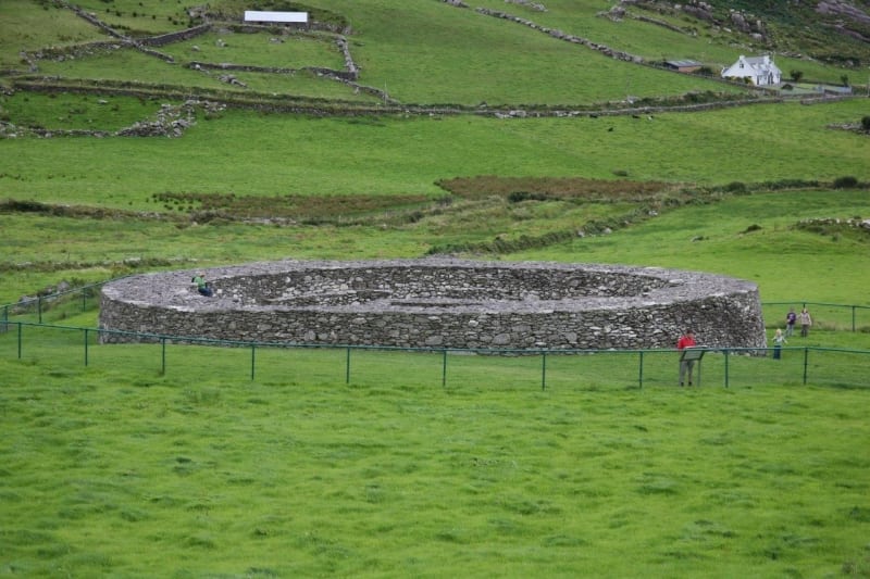
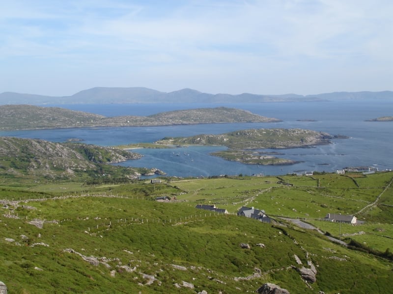
This stage follows quiet back roads, coastal paths and woodland tracks passing a number of ancient stone forts, the most famous of which is the impressive Loher Stone Fort. Loher (Irish: An Lóthar) fort was built by a local chieftan in the early 9th century has dry stone walls up to 3m high in places. This route also provides stunning views of Hogs Head, Ballinskelligs Bay, Bolus Head, the Skelligs, Derrynane Bay and Lambs head and passes through the stunning Derrynane National Park.
The Kerry Way is a long distance walking trail in County Kerry, Ireland and the longest of Irelands National Waymarked Trails at approximately 215 km (134 miles) long. The walking route officially begins and ends in Killarney but you can join the trail at any number of points along its length. The Kerry Way takes in the entire Iveragh Peninsula in an anti clockwise loop and is the walking alternative to the world famous Ring of Kerry scenic drive which follows a similar route.
Typically the entire route is broken down into 9 key stages of approximate equal length or duration. We have also broken some of these longer stages into smallers part to allow everyone irrespective of fitness or time available to experience one of the best and varied walks in Ireland.
Use our Map of Ireland and Sat Nav tool to get directions to any of the stage start points and our detailed maps and GPS on our ActiveME iPhone and Android App to find and follow the walking route live on screen and keep on track.
Gallery
Stage 6 of The Kerry Way long distance walking route is from Waterville to Caherdaniel. There are two options for this stage, an inland (28km) or coastal route (13km). This coastal route option for Stage 6 is a moderate 4 hour walk with one steady climb and the remainder only gentle undulations along the coast.
This stage follows quiet back roads, coastal paths and woodland tracks passing a number of ancient stone forts, the most famous of which is the impressive Loher Stone Fort. Loher (Irish: An Lóthar) fort was built by a local chieftan in the early 9th century has dry stone walls up to 3m high in places. This route also provides stunning views of Hogs Head, Ballinskelligs Bay, Bolus Head, the Skelligs, Derrynane Bay and Lambs head and passes through the stunning Derrynane National Park.
The Kerry Way is a long distance walking trail in County Kerry, Ireland and the longest of Irelands National Waymarked Trails at approximately 215 km (134 miles) long. The walking route officially begins and ends in Killarney but you can join the trail at any number of points along its length. The Kerry Way takes in the entire Iveragh Peninsula in an anti clockwise loop and is the walking alternative to the world famous Ring of Kerry scenic drive which follows a similar route.
Typically the entire route is broken down into 9 key stages of approximate equal length or duration. We have also broken some of these longer stages into smallers part to allow everyone irrespective of fitness or time available to experience one of the best and varied walks in Ireland.
Use our Map of Ireland and Sat Nav tool to get directions to any of the stage start points and our detailed maps and GPS on our ActiveME iPhone and Android App to find and follow the walking route live on screen and keep on track.
