- Created: August 28, 2012 10:33 am
- Updated: December 12, 2017 11:01 am
- Distance Instructions
- Distance 103 km
- Time 0 s
- Speed 0.0 km/h
- Min altitude 85 m
- Peak 629 m
- Climb 2288 m
- Descent 2191 m
This walking route is a moderate to strenuous 3 to 4 day (76 km) walking trail taking in a section of the Wicklow Way and St. Kevins Way Pilgrimage Route.
The Saint Kevin's Way is a 30km (19 mile) long pilgrim path in County Wicklow, Ireland which begins in the village of Hollywood, crosses the Wicklow Gap, and ends at the remains of the medieval monastery in Glendalough. An alternative spur route begins at Valleymount and joins the main trail at Ballinagee Bridge. It is typically completed in one day. The trail follows in the footsteps of Saint Kevin who crossed the Wicklow Mountains and founded the monastery at Glendalough in the 6th century.The journey later became a route of pilgrimage for visitors to Glendalough and is one of many medieval pilgrim paths around Ireland.
The Wicklow Way is a moderate to strenuous 4 to 10 day (130 km) long distance walking trail in Counties Dublin, Wicklow and Carlow and one of the most popular National Waymarked Trails in Ireland. The walking route officially begins in Marlay Park in Dublin, through County Wicklow and ends in the village of Clonegal in County Carlow but it can be done in either direction and you can join the route at any number of points along its length.
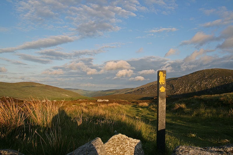
The trail is well signposted with the universal yellow ‘walking man’ symbol and directional arrows to show you the way. It is typically completed in 5–7 days with low-level walking in Dublin, to more strenuous mountain walks in Wicklow and finishing with walks on rolling countryside in Carlow. The route consists of mountain trails, country paths through fields and forests and quiet side roads . The route has much to offer with many attractions to see and plenty of things to do and places to stay along the way.
The entire route is normally broken down into 6 main walkings stages of equal length. However, we have broken these longer main stages into shortern parts (shown at the bottom of the page) to allow everyone irrespective of fitness or time available to experience one of the best and most popular walks in Ireland.
There are plenty of routes available, so find a route that is right for you or your group. Plan your walk by estimating you walking time, checking the weather and the sunrise sunset times on our website https://www.activeme.ie/useful-info/planning-a-trip/ and please remember you are only as fast as the slowest member of your group!
Use our Map of Ireland and Sat Nav tool to get directions to any of the stage start points and our detailed maps and GPS on our ActiveME iPhone and Android App to find and follow the walking route live on screen and keep on track. At all times, our maps and App should be used in conjunction with proper map and compass navigation techniques. Feel free to send us your photos and add you own star rating, comments or suggestions below.
Gallery
This walking route is a moderate to strenuous 3 to 4 day (76 km) walking trail taking in a section of the Wicklow Way and St. Kevins Way Pilgrimage Route.
The Saint Kevin’s Way is a 30km (19 mile) long pilgrim path in County Wicklow, Ireland which begins in the village of Hollywood, crosses the Wicklow Gap, and ends at the remains of the medieval monastery in Glendalough. An alternative spur route begins at Valleymount and joins the main trail at Ballinagee Bridge. It is typically completed in one day. The trail follows in the footsteps of Saint Kevin who crossed the Wicklow Mountains and founded the monastery at Glendalough in the 6th century.The journey later became a route of pilgrimage for visitors to Glendalough and is one of many medieval pilgrim paths around Ireland.
The Wicklow Way is a moderate to strenuous 4 to 10 day (130 km) long distance walking trail in Counties Dublin, Wicklow and Carlow and one of the most popular National Waymarked Trails in Ireland. The walking route officially begins in Marlay Park in Dublin, through County Wicklow and ends in the village of Clonegal in County Carlow but it can be done in either direction and you can join the route at any number of points along its length.
The trail is well signposted with the universal yellow ‘walking man’ symbol and directional arrows to show you the way. It is typically completed in 5–7 days with low-level walking in Dublin, to more strenuous mountain walks in Wicklow and finishing with walks on rolling countryside in Carlow. The route consists of mountain trails, country paths through fields and forests and quiet side roads . The route has much to offer with many attractions to see and plenty of things to do and places to stay along the way.
The entire route is normally broken down into 6 main walkings stages of equal length. However, we have broken these longer main stages into shortern parts (shown at the bottom of the page) to allow everyone irrespective of fitness or time available to experience one of the best and most popular walks in Ireland.
There are plenty of routes available, so find a route that is right for you or your group. Plan your walk by estimating you walking time, checking the weather and the sunrise sunset times on our website https://www.activeme.ie/useful-info/planning-a-trip/ and please remember you are only as fast as the slowest member of your group!
Use our Map of Ireland and Sat Nav tool to get directions to any of the stage start points and our detailed maps and GPS on our ActiveME iPhone and Android App to find and follow the walking route live on screen and keep on track. At all times, our maps and App should be used in conjunction with proper map and compass navigation techniques. Feel free to send us your photos and add you own star rating, comments or suggestions below.
