- Created: August 28, 2012 11:32 am
- Updated: December 12, 2017 11:02 am
- Distance Instructions
- Distance 14 km
- Time 0 s
- Speed 0.0 km/h
- Min altitude 7 m
- Peak 92 m
- Climb 136 m
- Descent 145 m
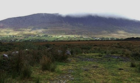
The fourth part of Stage 4 on The Kerry Way long distance walking route is from Foilmore to Cahersiveen, County Kerry in the southwest of Ireland. This is an easy to moderate 3.5 hour (11 km) walking route along quiet country roads, tracks and through woodland and finishing in Cahersiveen where you can spend the night and take a trip to the unmissable Valentia Island. This walk can be done in either direction. There are also some greats walks around Cahersiveen including Bentee Mountain (376m) Loop Walk, Knocknatobar Mountain (690m) and Dolus Head Loop Walk.
The Kerry Way is a long distance walking trail in County Kerry, Ireland and the longest of Irelands National Waymarked Trails at approximately 215 km (134 miles) long. The walking route officially begins and ends in Killarney but you can join the trail at any number of points along its length. The Kerry Way takes in the entire Iveragh Peninsula in an anti clockwise loop and is the walking alternative to the world famous Ring of Kerry scenic drive which follows a similar route.
Typically the entire route is broken down into 9 key stages of approximate equal length or duration. We have also broken some of these longer stages into smallers part to allow everyone irrespective of fitness or time available to experience one of the best and varied walks in Ireland.
Use our Map of Ireland and Sat Nav tool to get directions to any of the stage start points and our detailed maps and GPS on our ActiveME App to find and follow the walking route live on screen and keep on track. At all times, our maps and App should be used in conjunction with proper map and compass navigation techniques. Feel free to send us your photos and add you own star rating, comments or suggestions below.
Gallery
The fourth part of Stage 4 on The Kerry Way long distance walking route is from Foilmore to Cahersiveen, County Kerry in the southwest of Ireland. This is an easy to moderate 3.5 hour (11 km) walking route along quiet country roads, tracks and through woodland and finishing in Cahersiveen where you can spend the night and take a trip to the unmissable Valentia Island. This walk can be done in either direction. There are also some greats walks around Cahersiveen including Bentee Mountain (376m) Loop Walk, Knocknatobar Mountain (690m) and Dolus Head Loop Walk.
The Kerry Way is a long distance walking trail in County Kerry, Ireland and the longest of Irelands National Waymarked Trails at approximately 215 km (134 miles) long. The walking route officially begins and ends in Killarney but you can join the trail at any number of points along its length. The Kerry Way takes in the entire Iveragh Peninsula in an anti clockwise loop and is the walking alternative to the world famous Ring of Kerry scenic drive which follows a similar route.
Typically the entire route is broken down into 9 key stages of approximate equal length or duration. We have also broken some of these longer stages into smallers part to allow everyone irrespective of fitness or time available to experience one of the best and varied walks in Ireland.
Use our Map of Ireland and Sat Nav tool to get directions to any of the stage start points and our detailed maps and GPS on our ActiveME App to find and follow the walking route live on screen and keep on track. At all times, our maps and App should be used in conjunction with proper map and compass navigation techniques. Feel free to send us your photos and add you own star rating, comments or suggestions below.
