- Created: August 28, 2012 10:32 am
- Updated: December 12, 2017 11:02 am
- Distance Instructions
- Distance 9 km
- Time 0 s
- Speed 0.0 km/h
- Min altitude 95 m
- Peak 276 m
- Climb 199 m
- Descent 198 m
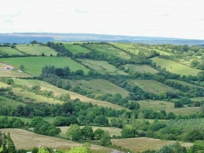
The Ballycroum Forest loop walk is a moderate 2.5 hour (7km) loop walking route in county Clare, Ireland. The walk passes through a forest and open ground with a variety of wildlife, ancient tombs and other interesting places. The loop walk is part of the Network of National Looped Walks and is marked using the standard purple National Looped Walk directional arrows.
Use our Map of Ireland and Sat Nav tool to get directions and our detailed maps and GPS on our ActiveME App to find and follow the walk live on screen and keep on track. At all times, our maps and App should be used in conjunction proper map and compass navigation techniques.
Gallery
The Ballycroum Forest loop walk is a moderate 2.5 hour (7km) loop walking route in county Clare, Ireland. The walk passes through a forest and open ground with a variety of wildlife, ancient tombs and other interesting places. The loop walk is part of the Network of National Looped Walks and is marked using the standard purple National Looped Walk directional arrows.
Use our Map of Ireland and Sat Nav tool to get directions and our detailed maps and GPS on our ActiveME App to find and follow the walk live on screen and keep on track. At all times, our maps and App should be used in conjunction proper map and compass navigation techniques.
