- Created: August 28, 2012 11:32 am
- Updated: December 12, 2017 11:02 am
- Distance Instructions
- Distance 37 km
- Time 0 s
- Speed 0.0 km/h
- Min altitude 7 m
- Peak 418 m
- Climb 963 m
- Descent 938 m
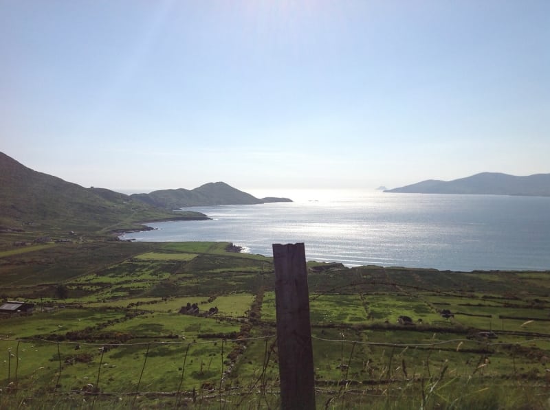
Stage 6 on The Kerry Way long distance walking route is from Waterville to Caherdaniel, County Kerry in the southwest of Ireland. This is a long strenuous 8 to 12 hour (29 km) walking route along an inland route option with one steep climb and the remainder only moderate undulations in height. The boggy terrain can make progress slow but you also get nice walking on quiet country roads and mountain ridges and get some great rewarding views of Lough Currane, Waterville, Ballinskelligs Bay, the Atlantic Ocean, Beara Peninsulam Mullaghbeg (509m) and Eagles Hill (549m) along the way.
The walk can be done in either direction. From Waterville you retrace a section of the last stage to Mastergeehy, then follow the trail over spur of An Gleann Beag (484m) followed by some walking on quiet back roads before crossing the Capall River and passing between Eagles Hill (549m) and Staigue mountain (459m) and lastly decending gently along the Old Green Road to Caherdaniel.
The Kerry Way is a long distance walking trail in County Kerry, Irelandand the longest of Irelands National Waymarked Trails at approximately 215 km (134 miles) long. The walking route officially begins and ends in Killarney but you can join the trail at any number of points along its length. The Kerry Way takes in the entire Iveragh Peninsula in an anti clockwise loop and is the walking alternative to the world famous Ring of Kerry scenic drive which follows a similar route.
Typically the entire route is broken down into 9 key stages of approximate equal length or duration. We have also broken some of these longer stages into smallers part to allow everyone irrespective of fitness or time available to experience one of the best and varied walks in Ireland.
Use our Map of Ireland and Sat Nav tool to get directions to any of the stage start points and our detailed maps and GPS on our ActiveME iPhone and Android App to find and follow the walking route live on screen and keep on track. At all times, our maps and App should be used in conjunction with proper map and compass navigation techniques. Feel free to send us your photos and add you own star rating, comments or suggestions below.
Gallery
Stage 6 on The Kerry Way long distance walking route is from Waterville to Caherdaniel, County Kerry in the southwest of Ireland. This is a long strenuous 8 to 12 hour (29 km) walking route along an inland route option with one steep climb and the remainder only moderate undulations in height. The boggy terrain can make progress slow but you also get nice walking on quiet country roads and mountain ridges and get some great rewarding views of Lough Currane, Waterville, Ballinskelligs Bay, the Atlantic Ocean, Beara Peninsulam Mullaghbeg (509m) and Eagles Hill (549m) along the way.
The walk can be done in either direction. From Waterville you retrace a section of the last stage to Mastergeehy, then follow the trail over spur of An Gleann Beag (484m) followed by some walking on quiet back roads before crossing the Capall River and passing between Eagles Hill (549m) and Staigue mountain (459m) and lastly decending gently along the Old Green Road to Caherdaniel.
The Kerry Way is a long distance walking trail in County Kerry, Irelandand the longest of Irelands National Waymarked Trails at approximately 215 km (134 miles) long. The walking route officially begins and ends in Killarney but you can join the trail at any number of points along its length. The Kerry Way takes in the entire Iveragh Peninsula in an anti clockwise loop and is the walking alternative to the world famous Ring of Kerry scenic drive which follows a similar route.
Typically the entire route is broken down into 9 key stages of approximate equal length or duration. We have also broken some of these longer stages into smallers part to allow everyone irrespective of fitness or time available to experience one of the best and varied walks in Ireland.
Use our Map of Ireland and Sat Nav tool to get directions to any of the stage start points and our detailed maps and GPS on our ActiveME iPhone and Android App to find and follow the walking route live on screen and keep on track. At all times, our maps and App should be used in conjunction with proper map and compass navigation techniques. Feel free to send us your photos and add you own star rating, comments or suggestions below.
