- Created: April 15, 2014 10:07 pm
- Updated: December 12, 2017 10:58 am
- Distance Instructions
- Distance 17 km
- Time 0 s
- Speed 0.0 km/h
- Min altitude 143 m
- Peak 761 m
- Climb 731 m
- Descent 731 m
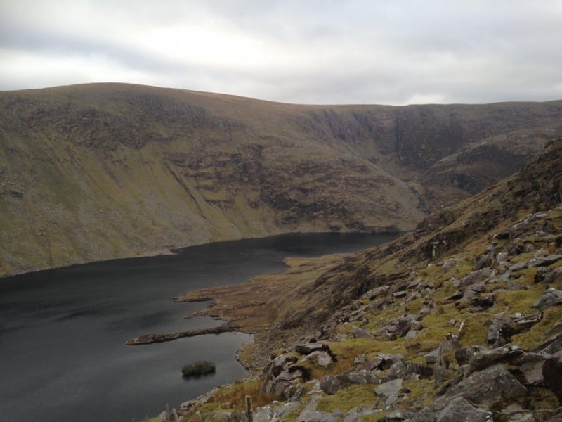
The Coomasaharn Horseshoe Loop Walk is a moderate 4 to 50 hour (12 km) hiking trail over several mountain peaks around the stunning Coomasaharn Lake near Glenbeigh village, Co. Kerry. This walk is a pure hidden gem and one of the best and most scenic loop walks in the country....but don't tell anybody!! The fact that these mountains are so close to the mighty and famous MacGillycuddy Reeks Mountains less than 10km to the east means that few visit them in comparison. View the route map and Gps directions below and also on our Free Apps on iPhone and Android here
The route starts in the remote Coomasaharn valley which is steeped in history and mythology. The walk passes through an area where Fionn Mac Cumhal of Irish Mythology and the Fianna, his army of warriors and hunters hunted deer with their famous pack of 500 Irish Wolf Hounds. Seefin, a nearby Mountain translates to Suí Finn in Irish meaning ‘the Seat of Finn’ (fionn). According to legend, Queen Maeve‘s son Ciar was the ancestor of the Ciarraige tribe that came to rule Killarney, from whom the name Ciarrai / Kerry is derived. The Iron Age 500BC to 300AD in Ireland is associated with the heroic tales of the Fianna and the Red Branch Knights. The fact that these Irish Mythology names of places and mountains have survived for so long, suggests that these were real people that lived, stories were told about them, and over time these stories were embellished with magic, fantasy and myth to keep them alive.
Whether you believe tales of Irish Mythology are based in fact or are just fiction, either way it is evident that this area has been inhabited for over 4,500 years by peoples who we know very little about. There is clear evident of ancient paths used over 4,500 years ago during the Bronze Age, early Christian routes and also medieval coaching roads throughout the area. These mountains and valleys are also full of amazing archaeological artefacts such as Rock Art from over the 4,500 year ago and the unique Ogham stones of Drung Hill.
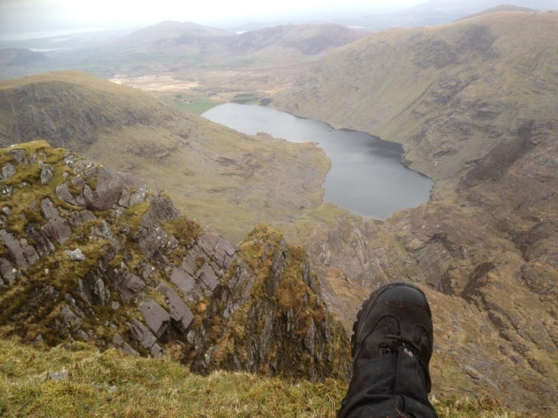
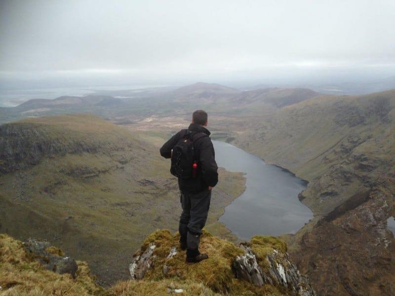
What makes this route special and makes it stand out from many walks on the MacGillycuddy's Reeks is the 360 degree scenic views of Dingle Bay, Rossbeigh and Inch Beaches to the north, the Skellig Coast, Valentia Island and Waterville to the West, Kenmare Bay and mountains to the south and the might peaks of the MacGillycuddy's Reeks to the east.
To get to the start point, drive approximately 4.5km (3 miles) west of Glenbeigh on the main Ring of Kerry road before turning left at the sign for Coomasaharn Lake. Once on this road, take a right at the next T-junction and the parking area will be 2.5km further on. Park here at the roadside making sure you leave room for other cars to pass.
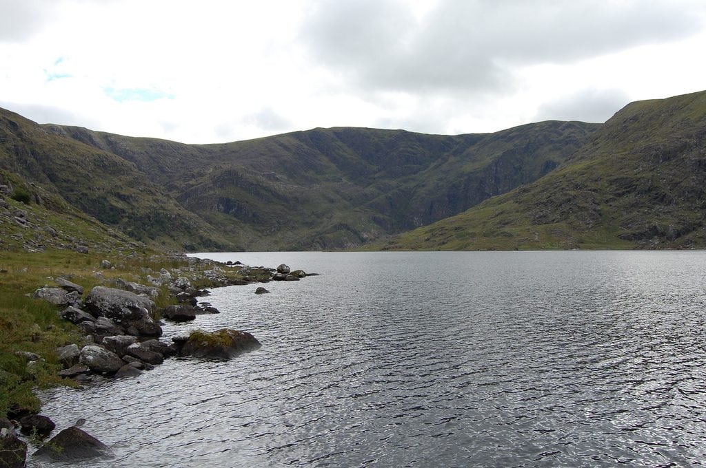
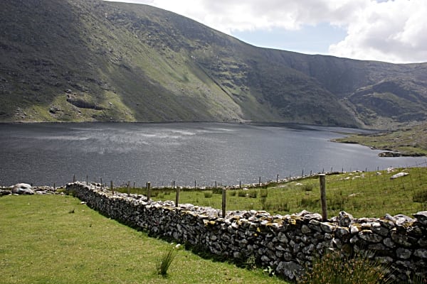
The route is best completed in an anti-clockwise direction. Starting in an area full of ancient Rock Art, follow the small roadway and climbs towards the nearby mountain to your west. The peaceful and remote Coomasaharn Horseshoe walking route then follows along the mountain ridge that surrounds the beautiful Coomasaharn Lake and valley below visiting many peaks including Coomreagh Mountain (593m), Keamconneragh mountain or Teermoyle Tooth (608m), Teermoyle Mountain (760m), Coomacarrea mountain or An Tráigh (772m), Meenteog (715m) and descending the eastern side of Knocknaman (561m) and finishing the walk skirting the shores of Coomnagrossaun Lake and walking through lovey green fields and bubbling streams.
Use our Map of Ireland and Sat Nav tool to get directions to any of the stage start points and our detailed maps and GPS on our ActiveME App to find and follow the walking route live on screen and keep on track. At all times, our maps and App should be used in conjunction with proper map and compass navigation techniques.
The Coomasaharn Horseshoe Loop Walk is a moderate 4 to 50 hour (12 km) hiking trail over several mountain peaks around the stunning Coomasaharn Lake near Glenbeigh village, Co. Kerry. This walk is a pure hidden gem and one of the best and most scenic loop walks in the country….but don’t tell anybody!! The fact that these mountains are so close to the mighty and famous MacGillycuddy Reeks Mountains less than 10km to the east means that few visit them in comparison. View the route map and Gps directions below and also on our Free Apps on iPhone and Android here
The route starts in the remote Coomasaharn valley which is steeped in history and mythology. The walk passes through an area where Fionn Mac Cumhal of Irish Mythology and the Fianna, his army of warriors and hunters hunted deer with their famous pack of 500 Irish Wolf Hounds. Seefin, a nearby Mountain translates to Suí Finn in Irish meaning ‘the Seat of Finn’ (fionn). According to legend, Queen Maeve‘s son Ciar was the ancestor of the Ciarraige tribe that came to rule Killarney, from whom the name Ciarrai / Kerry is derived. The Iron Age 500BC to 300AD in Ireland is associated with the heroic tales of the Fianna and the Red Branch Knights. The fact that these Irish Mythology names of places and mountains have survived for so long, suggests that these were real people that lived, stories were told about them, and over time these stories were embellished with magic, fantasy and myth to keep them alive.
Whether you believe tales of Irish Mythology are based in fact or are just fiction, either way it is evident that this area has been inhabited for over 4,500 years by peoples who we know very little about. There is clear evident of ancient paths used over 4,500 years ago during the Bronze Age, early Christian routes and also medieval coaching roads throughout the area. These mountains and valleys are also full of amazing archaeological artefacts such as Rock Art from over the 4,500 year ago and the unique Ogham stones of Drung Hill.
What makes this route special and makes it stand out from many walks on the MacGillycuddy’s Reeks is the 360 degree scenic views of Dingle Bay, Rossbeigh and Inch Beaches to the north, the Skellig Coast, Valentia Island and Waterville to the West, Kenmare Bay and mountains to the south and the might peaks of the MacGillycuddy’s Reeks to the east.
To get to the start point, drive approximately 4.5km (3 miles) west of Glenbeigh on the main Ring of Kerry road before turning left at the sign for Coomasaharn Lake. Once on this road, take a right at the next T-junction and the parking area will be 2.5km further on. Park here at the roadside making sure you leave room for other cars to pass.
The route is best completed in an anti-clockwise direction. Starting in an area full of ancient Rock Art, follow the small roadway and climbs towards the nearby mountain to your west. The peaceful and remote Coomasaharn Horseshoe walking route then follows along the mountain ridge that surrounds the beautiful Coomasaharn Lake and valley below visiting many peaks including Coomreagh Mountain (593m), Keamconneragh mountain or Teermoyle Tooth (608m), Teermoyle Mountain (760m), Coomacarrea mountain or An Tráigh (772m), Meenteog (715m) and descending the eastern side of Knocknaman (561m) and finishing the walk skirting the shores of Coomnagrossaun Lake and walking through lovey green fields and bubbling streams.
Use our Map of Ireland and Sat Nav tool to get directions to any of the stage start points and our detailed maps and GPS on our ActiveME App to find and follow the walking route live on screen and keep on track. At all times, our maps and App should be used in conjunction with proper map and compass navigation techniques.
