- Created: December 27, 2012 11:32 am
- Updated: December 12, 2017 11:00 am
- Distance Instructions
- Distance 28 km
- Time 0 s
- Speed 0.0 km/h
- Min altitude 0 m
- Peak 170 m
- Climb 395 m
- Descent 374 m
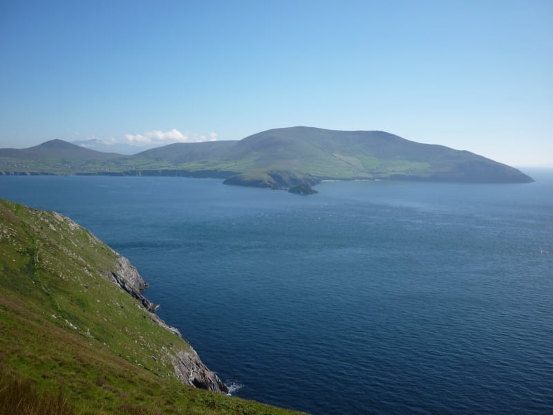
Stage 4 of The Dingle Way walking route is from Dingle to Dunquin. This is a moderate to strenuous 7 to 9 hour (20 km) walking route to Dunquin with the majority on quiet back roads, a few steady and steep climbs and spectacular views. The route follows the main road R559 for 1km, then uses the quiet back road to Ventry where you have a beautiful beach walk. From here the route rises, following the main road again for a short stretch where caution is advised before following the 100m to 160m contours on the slopes of Mount Eagle (516m) passing ancient Beehive Huts and spectacular views of Dingle Bay, the Blasket Islands and the rugged coastline. The last 3 km to the famous Dunquin pier is along the main narrow tourist road so caution is advised again.
The Dingle Way is a long distance trail around the Dingle Peninsula, County Kerry, Ireland. At 162-kilometre (101-mile) long it is one of the longest of Irelands National Waymarked Trails and is typically completed in 8 to 10 days. The walking route officially begins and ends in Tralee but you can join the trail at any number of points along its length. The Dingle Way takes in the entire Dingle Peninsula and is the walking alternative to the great scenic drive around the Dingle Peninsula, a spectacular figure of 8 loop which typically begins and ends in Tralee.
Typically the entire route is broken down into 9 key stages of approximate equal length or duration. We have also broken some of these longer stages into smallers part to allow everyone irrespective of fitness or time available to experience one of the best and varied walks in Ireland.
Use our Map of Ireland and Sat Nav tool to get directions to the start point and our detailed maps and GPS on our ActiveME iPhone App and Android App to find and follow the walking route live on screen and keep on track. At all times, our maps and App should be used in conjunction with proper map and compass navigation techniques. You are also advised to taking into account the weather and have permisson to access the lands. Feel free to send us your photos and add you own star rating, comments or suggestions below.
Gallery
Stage 4 of The Dingle Way walking route is from Dingle to Dunquin. This is a moderate to strenuous 7 to 9 hour (20 km) walking route to Dunquin with the majority on quiet back roads, a few steady and steep climbs and spectacular views. The route follows the main road R559 for 1km, then uses the quiet back road to Ventry where you have a beautiful beach walk. From here the route rises, following the main road again for a short stretch where caution is advised before following the 100m to 160m contours on the slopes of Mount Eagle (516m) passing ancient Beehive Huts and spectacular views of Dingle Bay, the Blasket Islands and the rugged coastline. The last 3 km to the famous Dunquin pier is along the main narrow tourist road so caution is advised again.
The Dingle Way is a long distance trail around the Dingle Peninsula, County Kerry, Ireland. At 162-kilometre (101-mile) long it is one of the longest of Irelands National Waymarked Trails and is typically completed in 8 to 10 days. The walking route officially begins and ends in Tralee but you can join the trail at any number of points along its length. The Dingle Way takes in the entire Dingle Peninsula and is the walking alternative to the great scenic drive around the Dingle Peninsula, a spectacular figure of 8 loop which typically begins and ends in Tralee.
Typically the entire route is broken down into 9 key stages of approximate equal length or duration. We have also broken some of these longer stages into smallers part to allow everyone irrespective of fitness or time available to experience one of the best and varied walks in Ireland.
Use our Map of Ireland and Sat Nav tool to get directions to the start point and our detailed maps and GPS on our ActiveME iPhone App and Android App to find and follow the walking route live on screen and keep on track. At all times, our maps and App should be used in conjunction with proper map and compass navigation techniques. You are also advised to taking into account the weather and have permisson to access the lands. Feel free to send us your photos and add you own star rating, comments or suggestions below.
