- Created: October 4, 2012 11:32 pm
- Updated: December 12, 2017 11:00 am
- Distance Instructions
- Distance 7 km
- Time 0 s
- Speed 0.0 km/h
- Min altitude 9 m
- Peak 88 m
- Climb 103 m
- Descent 103 m
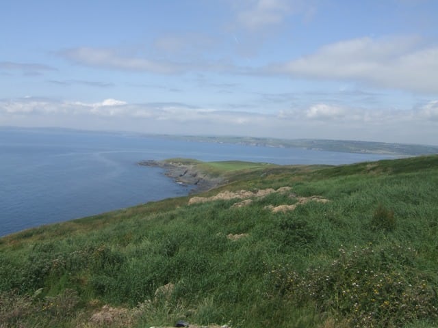
The Old Head of Kinsale Loop is an easy 1.5 hour (6 km) loop walking route on the famous Old Head of Kinsale with spectacular views at every turn with an optional spur walk to Garretstown beach in south County Cork, Ireland. Take this scenic walking route with you on our free App for iPhone and Android and share your photos on the ActiveMe facebook page.

- Places to Stay Near Kinsale: coming soon
- Places for Food Near Kinsale: coming soon
- Places for Entertainment Nearby: coming soon
- Local Walking Guide or Tour Guide: coming Soon
- Other greats Things to See and Do in the Area: coming soon
The Old Head is famous for a number of reasons:
- The scenery is just outstanding at every turn
- Ancient ruins of a fortified site built by the the Érainn (Fir Bolg) Celts, between 500 and 100 B.C.
- The Old Head Lighthouse built in the 17th century
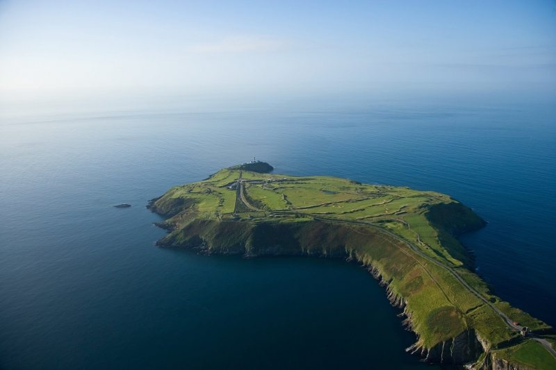
- The Old Head Golf Links course, one of the most remarkable locations in the history of links golf
- The nearby location where the RMS Lusitania was sunk by German torpedo in 1915 claiming 1,198 lives
The Old Head is a spectacular narrow promontory into the Atlantic Ocean which rises hundreds of feet from the sea with dramatic cliffs, is surrounded by the ocean on all sides and therefore has outstanding views along its entire length. Many of the golf holes play alongside these amazing cliffs.
On May 7 1915, the Lusitania passenger ship was torpedoed by a German U-Boat, 11 miles off the southern coast of Old Head in the declared 'zone of war' during WW2, claiming the lives of 1198 people. The wreck is in 300 ft (91 m) of water at 51°25′N 8°33′W.
When Greek writer Ptolomy wrote about Ireland/Iverni, he spoke about the ancient people know as Erainn, Fir Bolg or Belgae (same tribe), the second wave of Celtic people to settle in Ireland around 500 to 100 BC.
To get directions and to follw the route, use our Map of Ireland and Sat Nav tools on our website and our GPS maps on our free ActiveME iPhone and Android App to find and follow the walking route live on screen and keep on track. Feel free to add you own star rating and comments or suggestions below.
The Old Head of Kinsale Loop is an easy 1.5 hour (6 km) loop walking route on the famous Old Head of Kinsale with spectacular views at every turn with an optional spur walk to Garretstown beach in south County Cork, Ireland. Take this scenic walking route with you on our free App for iPhone and Android and share your photos on the ActiveMe facebook page.
- Places to Stay Near Kinsale: coming soon
- Places for Food Near Kinsale: coming soon
- Places for Entertainment Nearby: coming soon
- Local Walking Guide or Tour Guide: coming Soon
- Other greats Things to See and Do in the Area: coming soon
The Old Head is famous for a number of reasons:
- The scenery is just outstanding at every turn
- Ancient ruins of a fortified site built by the the Érainn (Fir Bolg) Celts, between 500 and 100 B.C.
- The Old Head Lighthouse built in the 17th century
- The Old Head Golf Links course, one of the most remarkable locations in the history of links golf
- The nearby location where the RMS Lusitania was sunk by German torpedo in 1915 claiming 1,198 lives
The Old Head is a spectacular narrow promontory into the Atlantic Ocean which rises hundreds of feet from the sea with dramatic cliffs, is surrounded by the ocean on all sides and therefore has outstanding views along its entire length. Many of the golf holes play alongside these amazing cliffs.
On May 7 1915, the Lusitania passenger ship was torpedoed by a German U-Boat, 11 miles off the southern coast of Old Head in the declared ‘zone of war’ during WW2, claiming the lives of 1198 people. The wreck is in 300 ft (91 m) of water at 51°25′N 8°33′W.
When Greek writer Ptolomy wrote about Ireland/Iverni, he spoke about the ancient people know as Erainn, Fir Bolg or Belgae (same tribe), the second wave of Celtic people to settle in Ireland around 500 to 100 BC.
To get directions and to follw the route, use our Map of Ireland and Sat Nav tools on our website and our GPS maps on our free ActiveME iPhone and Android App to find and follow the walking route live on screen and keep on track. Feel free to add you own star rating and comments or suggestions below.
