- Created: March 1, 2013 5:59 pm
- Updated: December 12, 2017 10:59 am
- Distance Instructions
- Distance 67 km
- Time 0 s
- Speed 0.0 km/h
- Min altitude 198 m
- Peak 918 m
- Climb 2177 m
- Descent 2267 m
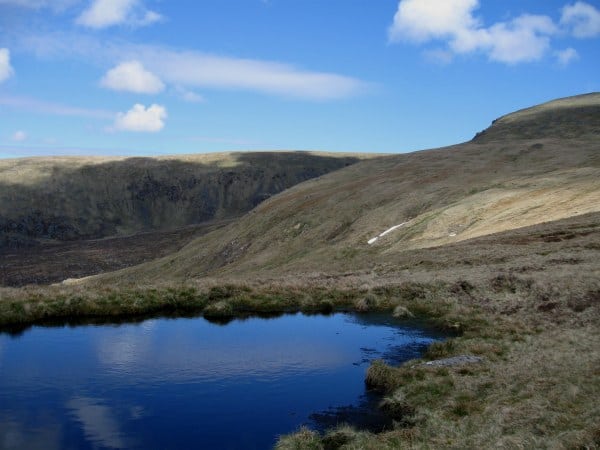
The Lug Walk or Lugnaquilla Walk is a long distance endurance walk taking on average 15 hours (51km and 2400m ascent) from Stone Cross near Bohernabreena, Co. Dublin over 18 mountain tops to the summit of Lugnaquilla Mountain (925m), Co. Wicklow and ending at Seskin in the Glen of Imaal. The majority of the walk is on open mountain terrain so therefore requires proper map and compass navigation techniques.
- The first organised Lug Walk took place in 1964 and is a serious test of stamina and navigational skills. Is was know as the Arnott-Russell Mountain Endurance Test and was organised by the Irish Mountaineering Club and Arnott & Co. An organised event now takes place each year in June for those interested in doing it with others and mountain leaders.
- Start: Stone Famine Cross at Bohernabreena, Grid Ref O 075207
- Seahan Mtn (648m)
- Corrig Mtn (618m)
- Seefingan Mtn (714m)
- Kippure Mtn (757m)
- Carrigvore Mtn (682m)
- Gravale Mtn (718m)
- Duff Hill Mtn (720m)
- Mullaghcleevaun East Mtn (795m)
- Mullaghcleevaun Mtn (849m)
- Barnacullian Mtn (714m)
- Stoney Top Mtn (718m)
- Tonelagee Mtn (817m)
- Conavalla Mtn (734m)
- Table Mtn (701m)
- Camenabologue (758m)
- Benleagh West (712m)
- Lugnaquilla Mtn (925m)
- Camara Hill (480m)
- Finish: Seskin/Glen of Imaal
Maps of the area include the Harvey's 25k scale map for the Wicklow Mountains and the OSi Discovery 50k scale map number 56
- The annual 'Lug Walk Challenge' is now a fully guided walk. Each small walking group is guided by an experienced leader with previous experience of climbing Lugnaquilla. You should not attempt the Lugnaquilla summit walk on your own unless you are an experienced hill walker with the correct mountaineering equipment and compass/map reading skills. There are no way-marked trails up to Lugnaquilla summit, nor are there many obvious landmarks. It is therefore very easy to get lost on this mountain range. Due to its height, Lugnaquilla is also prone to extreme changes in the weather. Mild conditions in Bray or Roundwood are no indication of the conditions on the mountain so be prepared.
- There are plenty of other routes to suit beginners to advanced walkers in the area, so please find a route that is right for you or your group. Plan your walk by checking the weather, sunrise sunset times and our hiking checklist on our website https://www.activeme.ie/useful-info/planning-a-trip/. Please remember that you are only as fast as the slowest member of your group! It is also better completed after a spell of dry weather and allow plenty of time.
- Use our Map of Ireland and Sat Nav tool to get directions to the start point and our detailed maps and GPS on our ActiveME iPhone App and Android App to find and follow the walking route live on screen and keep on track. At all times, our maps and App should be used in conjunction with proper map and compass navigation techniques. Feel free to send us your photos and add you own star rating, comments or suggestions below.
The Lug Walk or Lugnaquilla Walk is a long distance endurance walk taking on average 15 hours (51km and 2400m ascent) from Stone Cross near Bohernabreena, Co. Dublin over 18 mountain tops to the summit of Lugnaquilla Mountain (925m), Co. Wicklow and ending at Seskin in the Glen of Imaal. The majority of the walk is on open mountain terrain so therefore requires proper map and compass navigation techniques.
– The first organised Lug Walk took place in 1964 and is a serious test of stamina and navigational skills. Is was know as the Arnott-Russell Mountain Endurance Test and was organised by the Irish Mountaineering Club and Arnott & Co. An organised event now takes place each year in June for those interested in doing it with others and mountain leaders.
– Start: Stone Famine Cross at Bohernabreena, Grid Ref O 075207
– Seahan Mtn (648m)
– Corrig Mtn (618m)
– Seefingan Mtn (714m)
– Kippure Mtn (757m)
– Carrigvore Mtn (682m)
– Gravale Mtn (718m)
– Duff Hill Mtn (720m)
– Mullaghcleevaun East Mtn (795m)
– Mullaghcleevaun Mtn (849m)
– Barnacullian Mtn (714m)
– Stoney Top Mtn (718m)
– Tonelagee Mtn (817m)
– Conavalla Mtn (734m)
– Table Mtn (701m)
– Camenabologue (758m)
– Benleagh West (712m)
– Lugnaquilla Mtn (925m)
– Camara Hill (480m)
– Finish: Seskin/Glen of Imaal
Maps of the area include the Harvey’s 25k scale map for the Wicklow Mountains and the OSi Discovery 50k scale map number 56
– The annual ‘Lug Walk Challenge’ is now a fully guided walk. Each small walking group is guided by an experienced leader with previous experience of climbing Lugnaquilla. You should not attempt the Lugnaquilla summit walk on your own unless you are an experienced hill walker with the correct mountaineering equipment and compass/map reading skills. There are no way-marked trails up to Lugnaquilla summit, nor are there many obvious landmarks. It is therefore very easy to get lost on this mountain range. Due to its height, Lugnaquilla is also prone to extreme changes in the weather. Mild conditions in Bray or Roundwood are no indication of the conditions on the mountain so be prepared.
– There are plenty of other routes to suit beginners to advanced walkers in the area, so please find a route that is right for you or your group. Plan your walk by checking the weather, sunrise sunset times and our hiking checklist on our website https://www.activeme.ie/useful-info/planning-a-trip/. Please remember that you are only as fast as the slowest member of your group! It is also better completed after a spell of dry weather and allow plenty of time.
– Use our Map of Ireland and Sat Nav tool to get directions to the start point and our detailed maps and GPS on our ActiveME iPhone App and Android App to find and follow the walking route live on screen and keep on track. At all times, our maps and App should be used in conjunction with proper map and compass navigation techniques. Feel free to send us your photos and add you own star rating, comments or suggestions below.
