- Created: August 28, 2012 10:33 am
- Updated: December 12, 2017 11:01 am
- Distance Instructions
- Distance 8 km
- Time 0 s
- Speed 0.0 km/h
- Min altitude 224 m
- Peak 701 m
- Climb 601 m
- Descent 600 m
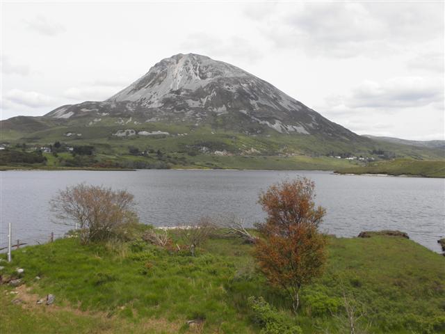
Rising from the surrounding landscape, the ERRIGAL Mountain (751m) and Mackoght Mountain Hiking Trail is a moderate to strenuous 6km (3.5 hr) loop walk to the popular, spectacular and iconic peak of Errigal Mountain, Donegals Highest mountain just to the east of Gweedore village in the Derryveagh Mountains in the north west of Ireland. Take this scenic walking route with you on our free App for iPhone and Android and share your photos on the ActiveMe facebook page.

- Places to Stay Near Errigal: coming soon
- Places for Food Near Errigal: coming soon
- Places for Entertainment Nearby: coming soon
- Local Walking Guide or Tour Guide: coming Soon
- Other greats Things to See and Do in the Area: coming soon

Located in the northwest of Ireland on the Wild Atlantic Way, this loop walk also takes in the nearby Mackoght mountain, also known as Wee (little) Errigal on the route and overlooks surrounding beauty of Dunlewy Lough the serene Glenveagh National Park and mountain range. Bring the walk and route map with you on our Free App here on iPhone and Android.
Well known for the pinky glow from its quartzite peak during a setting sun, the majestic Errigal Mountain is also the southernmost of the mountain chain known as the 'Seven Sisters' by locals which include Muckish, Crocknalaragagh, Aghla Beg, Ardloughnabrackbaddy, Aghla More, Mackoght and Errigal mountain. Despite its remote location, it is one of Irelands most popular mountain walking routes, possibly due to it compact nature at only 6km and 3.5 hrs to complete.
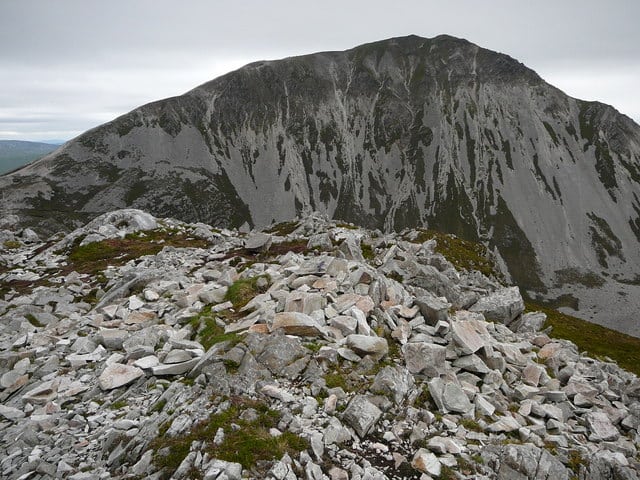
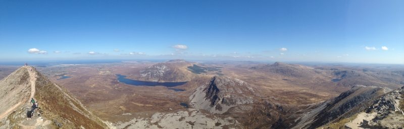
Starting from a carpark on the R251 road, the route follows a popular and obvious tourist path, firstly across slightly boggy land before the route starts climbing proper on steep shining quartzite scree with an accent of approx 525m from the carpark to the summit. From here relax and enjoy the spectacular views before you return along the same path to the car park or like most people you can take the exposed ridge walk known as ‘One Mans Pass’, which requires care if windy, to the twin summit known as Mackoght.
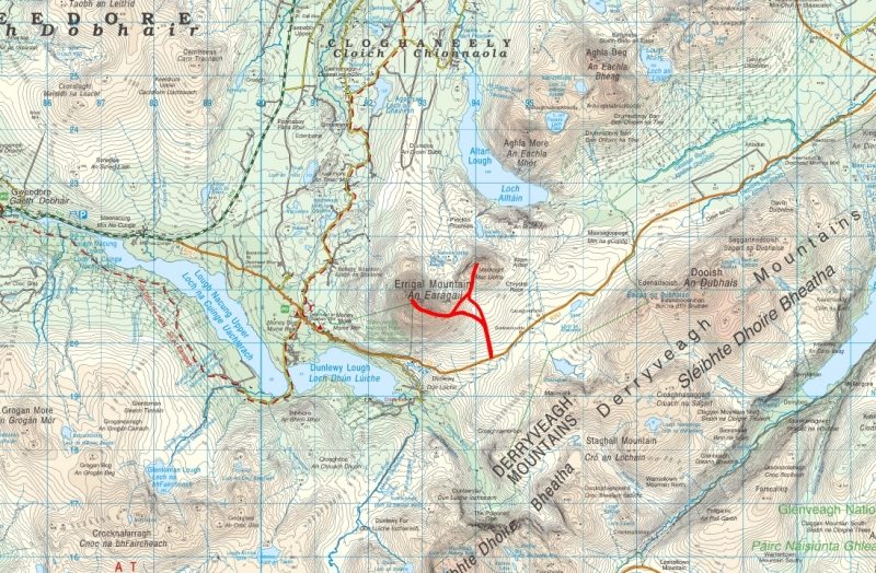
The map below shows the walking route but there are many other great walks in the area including:
- Errigal Way National Trail - Part of the Donegal Way (low level)
- Dunlewy Lough, Crookglass, Addernymore and Crockfadda mountain loop walk 18km (5-7 hrs)
- The Poisoned Glen Mountain Loop Walk 23km (7-9 hrs)
- Sliabh Sneachta Mountain Walk from Dunlewy 16km (5-7hrs)
Plan your walk by checking the weather, sunrise sunset times and our hiking checklist on our website https://www.activeme.ie/useful-info/planning-a-trip/. Please remember that you are only as fast as the slowest member of your group! If the weather is poor don't be afraid to cancel your walk and do some other walk, maybe a low level walk.
Use our Map of Ireland and Sat Nav tool to get directions to the start point and our detailed maps and GPS on our ActiveME iPhone App and Android App to find and follow the walking route live on screen and keep on track. At all times, our maps and App should only be used in conjunction with proper map and compass navigation techniques.
Gallery
Rising from the surrounding landscape, the ERRIGAL Mountain (751m) and Mackoght Mountain Hiking Trail is a moderate to strenuous 6km (3.5 hr) loop walk to the popular, spectacular and iconic peak of Errigal Mountain, Donegals Highest mountain just to the east of Gweedore village in the Derryveagh Mountains in the north west of Ireland. Take this scenic walking route with you on our free App for iPhone and Android and share your photos on the ActiveMe facebook page.
- Places to Stay Near Errigal: coming soon
- Places for Food Near Errigal: coming soon
- Places for Entertainment Nearby: coming soon
- Local Walking Guide or Tour Guide: coming Soon
- Other greats Things to See and Do in the Area: coming soon

Located in the northwest of Ireland on the Wild Atlantic Way, this loop walk also takes in the nearby Mackoght mountain, also known as Wee (little) Errigal on the route and overlooks surrounding beauty of Dunlewy Lough the serene Glenveagh National Park and mountain range. Bring the walk and route map with you on our Free App here on iPhone and Android.
Well known for the pinky glow from its quartzite peak during a setting sun, the majestic Errigal Mountain is also the southernmost of the mountain chain known as the ‘Seven Sisters‘ by locals which include Muckish, Crocknalaragagh, Aghla Beg, Ardloughnabrackbaddy, Aghla More, Mackoght and Errigal mountain. Despite its remote location, it is one of Irelands most popular mountain walking routes, possibly due to it compact nature at only 6km and 3.5 hrs to complete.
Starting from a carpark on the R251 road, the route follows a popular and obvious tourist path, firstly across slightly boggy land before the route starts climbing proper on steep shining quartzite scree with an accent of approx 525m from the carpark to the summit. From here relax and enjoy the spectacular views before you return along the same path to the car park or like most people you can take the exposed ridge walk known as ‘One Mans Pass’, which requires care if windy, to the twin summit known as Mackoght.
The map below shows the walking route but there are many other great walks in the area including:
- Errigal Way National Trail – Part of the Donegal Way (low level)
- Dunlewy Lough, Crookglass, Addernymore and Crockfadda mountain loop walk 18km (5-7 hrs)
- The Poisoned Glen Mountain Loop Walk 23km (7-9 hrs)
- Sliabh Sneachta Mountain Walk from Dunlewy 16km (5-7hrs)
Plan your walk by checking the weather, sunrise sunset times and our hiking checklist on our website https://www.activeme.ie/useful-info/planning-a-trip/. Please remember that you are only as fast as the slowest member of your group! If the weather is poor don’t be afraid to cancel your walk and do some other walk, maybe a low level walk.
Use our Map of Ireland and Sat Nav tool to get directions to the start point and our detailed maps and GPS on our ActiveME iPhone App and Android App to find and follow the walking route live on screen and keep on track. At all times, our maps and App should only be used in conjunction with proper map and compass navigation techniques.
