- Created: August 28, 2012 10:33 am
- Updated: December 12, 2017 11:01 am
- Distance Instructions
- Distance 18 km
- Time 0 s
- Speed 0.0 km/h
- Min altitude 71 m
- Peak 153 m
- Climb 104 m
- Descent 27 m
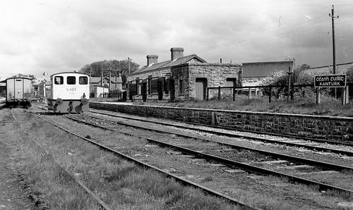
The old railway line from Banteer to Kanturk and onto Newmarket is 14km in length and opened in 1889. It opened up and changed the way of life for this rural part of north county Cork both socially and economically. As with many of the other rural railways, it closed to passenger traffic in 1947 and finally closed altogether in 1963. Although the railway originated at Banteer Station (extant), when the line was built was named Kanturk.
With the recent tourism and economic success of the Great Western Greenway cycle and walking route from Westport to Achill in Mayo, many other disused railway lines in Ireland are now under consideration for tourism upgrades. Some sections of this old railway line have the potential to be developed as walking and cycle routes. Local knowledge suggests that the sections with the best potential would be south of Kanturk Castle and the section beyond Kanturk with possible parking areas available for both. Thanks to Richard Norton for the local information and photos.
Use our Map of Ireland and Sat Nav tool to get directions to any point on the line and our detailed maps and GPS on our ActiveME iPhone App and Android App to find and follow the line live on screen and keep on track (excuse the pun!). At all times, our maps and App should be used in conjunction with proper map and compass navigation techniques and appropraite permissions from landowners. Feel free to send us your photos and add you own star rating, comments or suggestions below.
Gallery
The old railway line from Banteer to Kanturk and onto Newmarket is 14km in length and opened in 1889. It opened up and changed the way of life for this rural part of north county Cork both socially and economically. As with many of the other rural railways, it closed to passenger traffic in 1947 and finally closed altogether in 1963. Although the railway originated at Banteer Station (extant), when the line was built was named Kanturk.
With the recent tourism and economic success of the Great Western Greenway cycle and walking route from Westport to Achill in Mayo, many other disused railway lines in Ireland are now under consideration for tourism upgrades. Some sections of this old railway line have the potential to be developed as walking and cycle routes. Local knowledge suggests that the sections with the best potential would be south of Kanturk Castle and the section beyond Kanturk with possible parking areas available for both. Thanks to Richard Norton for the local information and photos.
Use our Map of Ireland and Sat Nav tool to get directions to any point on the line and our detailed maps and GPS on our ActiveME iPhone App and Android App to find and follow the line live on screen and keep on track (excuse the pun!). At all times, our maps and App should be used in conjunction with proper map and compass navigation techniques and appropraite permissions from landowners. Feel free to send us your photos and add you own star rating, comments or suggestions below.
