Below is a summary of the many varied projects completed by ActiveMe Tourism Media and Heritage Services from small map design jobs taking no more than a week to full scale major heritage projects lasting over 6 months.
Loop Head Heritage Trail Tourism Project on the Wild Atlantic Way
ActiveMe were commissioned in 2014 by The Heritage Council, Clare County Council and Failte Ireland to develop and design a pioneering heritage trail project for Loop Head, Co. Clare on the Wild Atlantic Way which also provided a template for developing a series of other future heritage trails and walking routes along the Wild Atlantic Way and Ireland’s Ancient East. This major community-based media project mapped and documented 14no. major Points of Interest (local heritage sites), history and culture of the Loop Head Peninsula and the 4no. Discovery Points along the Wild Atlantic Way.
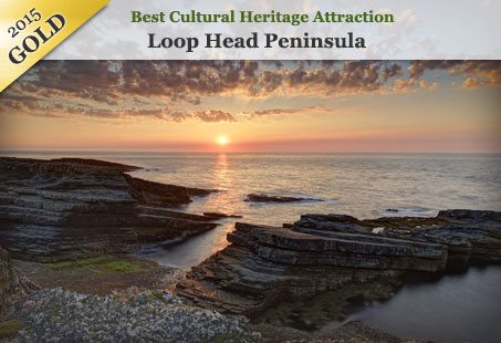
 In Nov 2015, to the delight of all involved, the Loop Head Heritage Trail was awarded a Gold First Prize in the World Responsible Tourism Awards at the World Travel Market London attended by over 50,000 tourism operators and professionals and worldwide media reach. The judges noted that the heritage trail is an international benchmark of best practice and ‘a fine example of local people taking ownership of their heritage and, in so doing, setting a new, shiny emerald onto Ireland’s tourism map’.
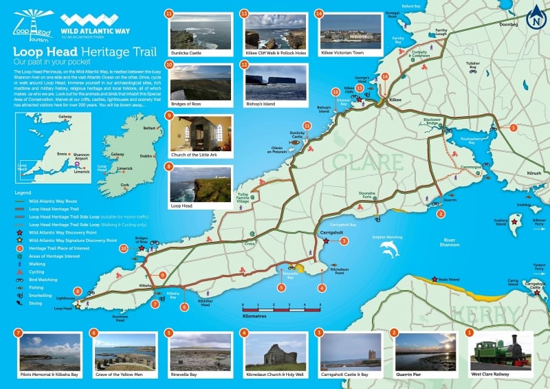
 ActiveMe worked with and interviewed local people well versed in the history and culture of the Loop Head and about life in this historic and scenic part of Ireland. As part of this project ActiveMe created a large online Database library of high quality ‘design ready’ media and information including detailed research and fresh new interpretive text for each of the 18no. heritage sites (over 15,000 words in total), 200 final professional photographs (over 2,000 taken), recorded audio interviews with 15 locals regarding the sites (55 audio snippets and 2 songs), GPS survey of 21 walking, cycles and driving routes, maps and other media to create a high quality Heritage Trail print map for tourists (as shown below).
Importantly, this online database can be used with existing products (tourism and business websites, etc) or to develop future tourism products such as smartphone Apps, websites, further Heritage Trials, walking routes, cycle routes, interpretation boards, print maps, online maps, brochures, Story Maps, audio guides, podcasts, social media and much more. This database can be viewed at https://wildatlanticway.omeka.net/.
See this project in the news – The Journal 04/11/15, The Examiner 28/11/14, Clare Champion, Irish Central 01/12/14, The Independent 07/12/14, The Clare Herald 28/11/14,
This project has been described as ‘global best practice’ in terms of sustainable tourism due to it’s local community focus.
Munster Vales Tourism Marketing Plan & Visitor Experience Itineraries
The Munster Vales Tourism Marketing Plan & Visitor Experience Itineraries was completed in early 2016 by ActiveMe Tourism and Heritage Services in association with Boland Marketing for Tipperary County Council on behalf of Munster Peaks Ltd. (Munster Vales) and was the first step towards building this new unique destination covering counties Tipperary, Waterford, Limerick and Cork and incorporating Irelands Ancient East. The approximate outline of the new Munster Vales area takes in the mountain ranges of Ballyhoura, Galtee, Knockmealdown, Comeragh, Slievenamon and Nagles. The project objective was to promote the geographical area as a new consistent brand, increase the socio-economic benefits of tourism in this rural area and provide an enhanced visitor experience. It also aimed to ensure a greater sense of understanding of the history, heritage, folklore and culture in the Munster Vales by connecting with and placing the local business and farming communities of the Munster Vales at the core of the plan.
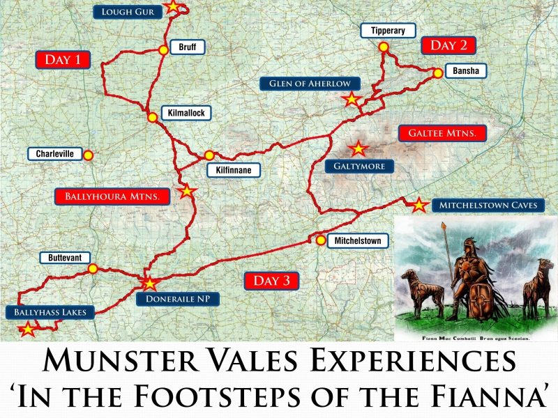
The Tourism Marketing Plan contained all traditional marketing elements of research, swot and gap analysis, existing offerings, market analysis, tourism content strategies, marketing material and products and importantly a practical action, operational and implementation plans based on realistic available budgets and detailed costings. In addition the plan also included practical Visitor Bundle Experiences (itineraries and holiday packages) designed and produced by ActiveMe and presented as ‘Stories’ which promote the Munster Vales through original, authentic, high quality, interesting and captivating tourism content i.e. ‘Your Story’. See sample map for our ‘Follow in the Footsteps of the Fianna’ drive below.
Blessington Lakeside Heritage Trail
ActiveMe were commissioned in 2015 to develop and design the Blessington Lakeside Heritage Trail, Co. Wicklow, a pioneering trail for Ireland’s Ancient East and a template for future trails and tourism products in the region. This project was undertaken in conjunction with local residents, Wicklow County Council, the Heritage Council and the Blessington Heritage and Tourism Group using a similar approach to the Loop Head Heritage Trail above. This was again a major community-based media project which included high quality tourist map design, photography and research of 10no. major Points of Interest (local heritage sites) around the lakes including the history and culture of area and its links with the 1916 Rising. We also created an online database which can be both used with existing products (tourism and business websites, etc) or used to develop future tourism products such as smartphone Apps, websites, further Heritage Trials, walking routes, cycle routes, interpretation boards, print maps, online maps, brochures, Story Maps, audio guides, podcasts, social media and much more. This database can be viewed at https://wicklowheritage.omeka.net/.

Kerry Way Folklore and Heritage Project – National Walking Trail
ActiveMe were commissioned in 2013 by Bealoideas Chiarraí (Kerry Folklore) in association with Kerry Group, South Kerry Development Partnership (SKDP), the Kerry County Council Heritage Officer and other partners to undertake this major new project which aimed to boost tourism and enhance the experience of those using the Kerry Way through incorporating the folklore and heritage of the route into their journey through the most modern communication methods such as phone apps and a website (next project phases), in addition to a complementary printed Trail Maps.
As part of the Kerry Way Folklore Project Phase 1, ActiveMe collected a large library of high quality digital information, 400 final photographs (4,500 taken), 10 hours of raw video (3 hour edited), 8 hours of recorded and transcribed audio interviews, over 400 points of interest research and mapped, and other media over 8 months to create both a printed tourism map and online database of information for 20km of the Kerry Way Walking Trail (180km). Once open to the public, this database can be viewed at https://kerryway.omeka.net/.
The projects overall aim was to increase tourism and help visitors to engage with the landscape and communities on the Kerry Way, collecting audio and video interviews with locals, folklore and point of interest information, photographs and video along the route. With other project Phases already underway, the Phase 1 information and Trail Map have yet to be published by the client but once they are made public we will add them here.
This project is the first Folklore Project of its kind to blend a wide range of disciplines including digital mapping, photography, video, heritage research, Points of Interest, interviews with local residents, audio and other skills and has become a benchmark heritage project in Ireland. Below is a audio visual video snap shot of the project by Valerie O’Sullivan as a gift to the locals who participated in the project. It brilliantly summarises the locations and information gathered along the 20km route on the Kerry Way accompanied by glorious music from local musician Niamh Ní Charra.
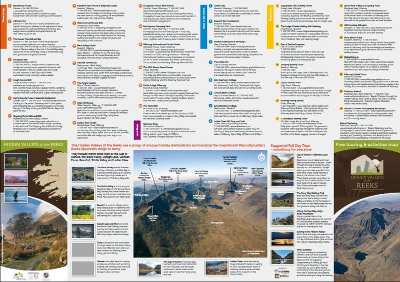
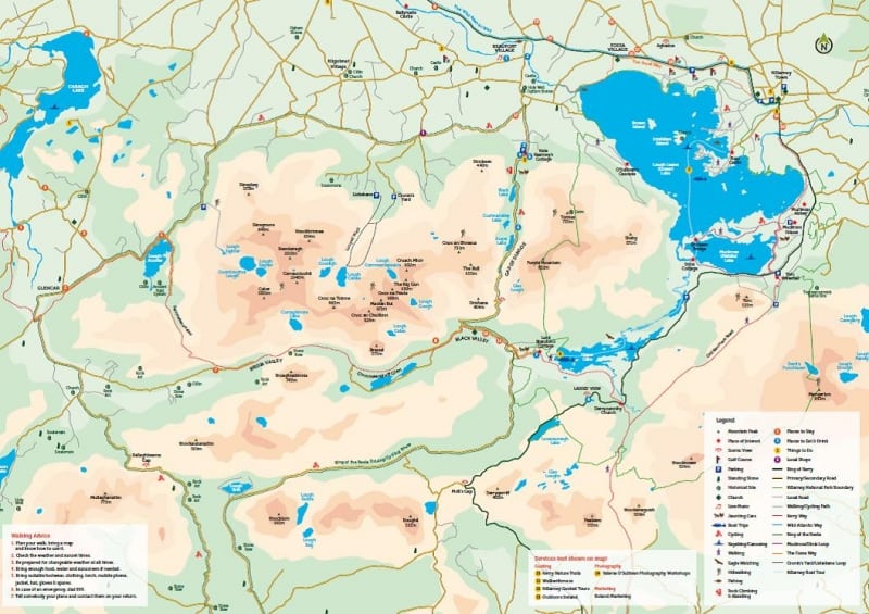
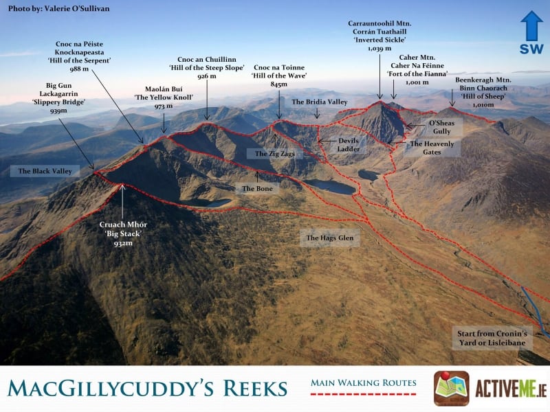
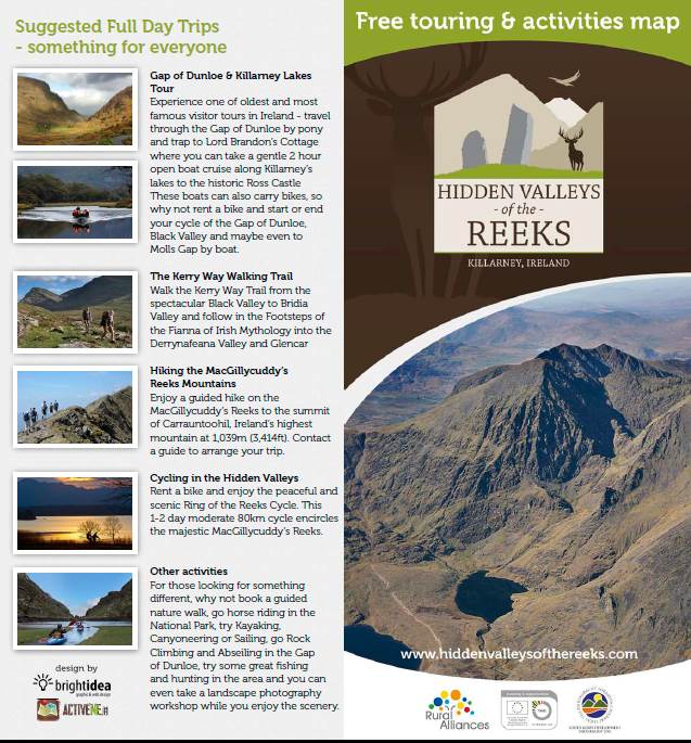
Hidden Valleys of the Reeks Tourist Brochure Map, Killarney – Local Tourism Group
ActiveMe worked with the newly formed ‘Hidden Valleys of the Reeks’ tourism group in 2014 to develop a high quality map brochure to increase tourism and keep visitors in the area longer. This tourism group is made up of over 40 small rural local businesses located at the foothills of the MacGillycuddy’s Reeks mountains, Co. Kerry.
ActiveMe worked closely and consulted with the group at all stages to develop their Identity, Branding, Group Logo and Map Layout and Design. Most importantly ActiveMe undertook all the Map Content tasks which are often overlooked but can represent up to 80% of all costs and time. This included all descriptive text for each business, destination, point of interest and suggest itineraries; walking and cycling route surveys, business GPS locations, heritage, professional photography, GPS info, and more.
The design is a doubled sided full colour A2 sized map which folds to DL size which was essential to show the level of detail and content required whilst also being clear, easy to understand, easy to display on brochure shelves and easy for tourists to carry.
Killarney Walking Festival – Client: Gleneagle Hotel
ActiveMe have been involved since the conception of the Killarney Walking Festival in 2014. ActiveMe undertook GPS surveys and mapped each of the 12 walking routes for the festival. In addition to creating a dedicated Festival Page on the ActiveME Website, each walk was then added to the ActiveMe Travel Guide along with links back to the festival website and booking pages for maximum exposure to the over 250,000 annual users on ActiveMe. See the walks here www.activeme.ie/useful-info/killarney-walking-festival/. ActiveMe was also involved in the promotional aspects of the festival from Launch PR to Guiding. See the official website here www.killarneywalkingfestival.ie
![]()
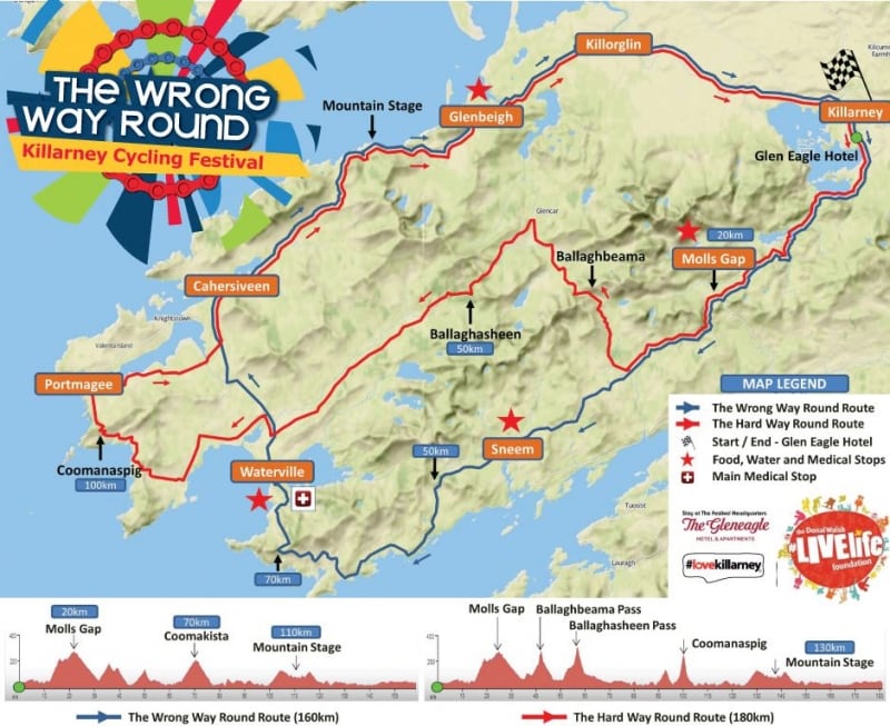
Killarney Cycle Festival Route Map Design – Client: Gleneagle Hotel
ActiveME designed the route map for the inaugural Killarney Cycling Festival 2014 in addition to adding the digital routes to the ActiveMe Travel Guide for maximum exposure to potential riders. See the official website here www.killarneycyclingfestival.com
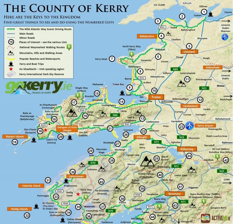
Map of Kerry Design – Client: GoKerry.ie
ActiveMe worked with GoKerry.ie to design and develop a detailed map of Kerry for a Travel Supplement on the Independent paper. The aim of the map was to increase tourism and display large amounts of information and place names whilst also being clear and easy to understand. GoKerry.ie is a marketing group for the entire county of Kerry with members spanning the length and breath of the county and subsequently the map was required to show every possible tourist destination with minimal bias.
Using a well designed numbering system, ActiveMe was able to relate the map to a lists of over 500 Places to See and Things to Do divided into categories such as Top Things to See and Do in Kerry, Walks, Cycles, Mountain areas, Beaches, Fishing Spots, Scenic Drives, Parks and Gardens, Heritage Sites, Castles, Museums, Golf Courses, Water Sports, Bird Watching, Horse Riding and Wild Atlantic WAy Discovery Points. ActiveMe undertook all the Map Content tasks which are often overlooked but can represent up to 80% of all costs and time including all research of the above lists and GPS location of each point.
This map was subsequently edited to suit a GoKerry Guidebook called the The Kingdom of Kerry published in 2015.
Killarney Adventure Race – Digital GPS Route Mapping Provider
ActiveMe worked with Elite Event Management to undertake detailed GPS surveys and mapping for the Killarney Adventure Race, Ireland’s biggest adventure race on in October and March of each year. The race involves running, kayaking and cycling some of the most rugged landscapes and breathtaking scenery in the world.
In addition to creating a dedicated Page on the ActiveME Website, each stage route was GPS surveyed and then added to the ActiveMe Travel Guide along with links back to the official Race website and booking pages for maximum exposure to the over 250,000 annual users on the ActiveMe website and free Apps. See the various route options and race stages by ActiveMe here www.activeme.ie/useful-info/killarney-adventure-race-2013/. Take our route maps with you and follow using GPS by downloading our Free ActiveMe App on iPhone and Android. See the official website here www.killarneyadventurerace.com
![]()
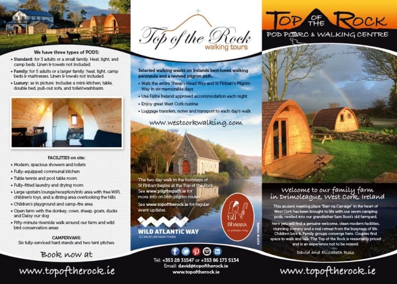
Tourism Brochure Design – Top of the Rock, Drimoleague
ActiveMe worked with David Ross of the Top of the Rock Pod Pairc and Walking Centre to design and develop their new Brochure incorporating their Glamping business in addition to maps for their West Cork Walking business which provides guided and self guided walks and accommodation along the Sheeps Head Way and St. Finbars Pilgrim way walking trail. ActiveMe undertook all the Map Content tasks which are often overlooked but can represent up to 80% of all costs and time. This included all walking route surveys, points of interest, business GPS locations and more. The design is a doubled sided full colour A4 sized map which folds to DL size which allowed the maps to be clear, easy to understand, easy to display on brochure shelves and easy for tourists to carry.
In addition to the Map Design ActiveMe also created an ActiveMe business page profile for Top of the Rock and West Cork Walking on the ActiveMe Travel Guide along with links back to their own websites, email and booking pages for maximum exposure to the over 250,000 annual users on ActiveMe website and Free Apps.
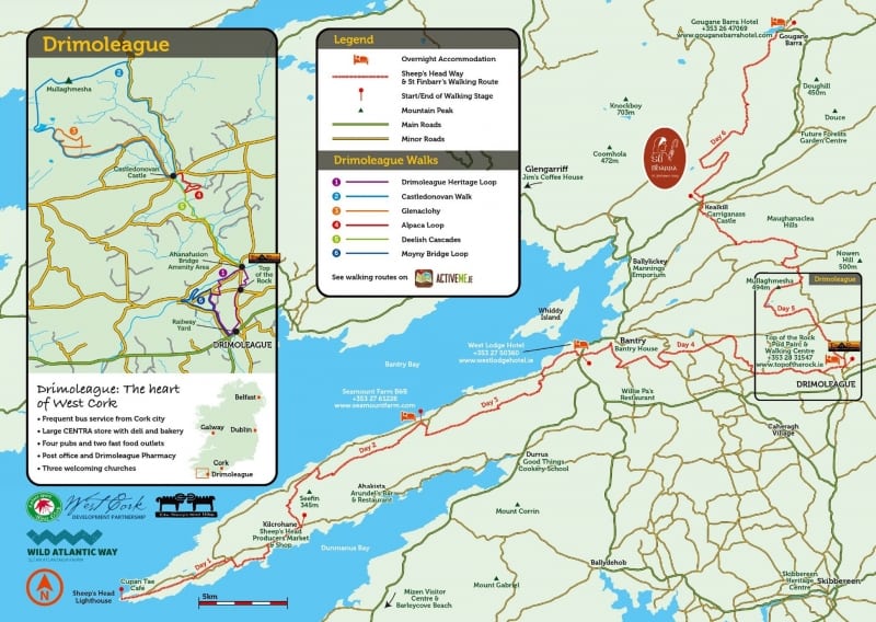
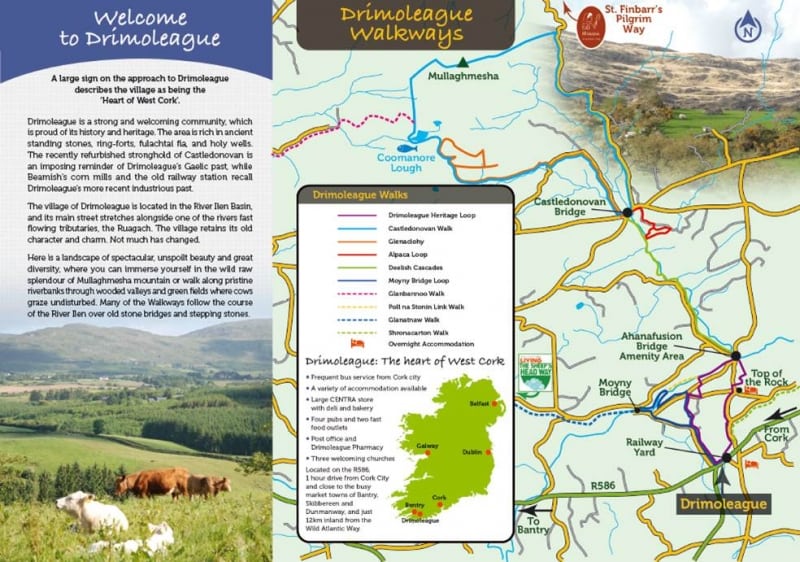
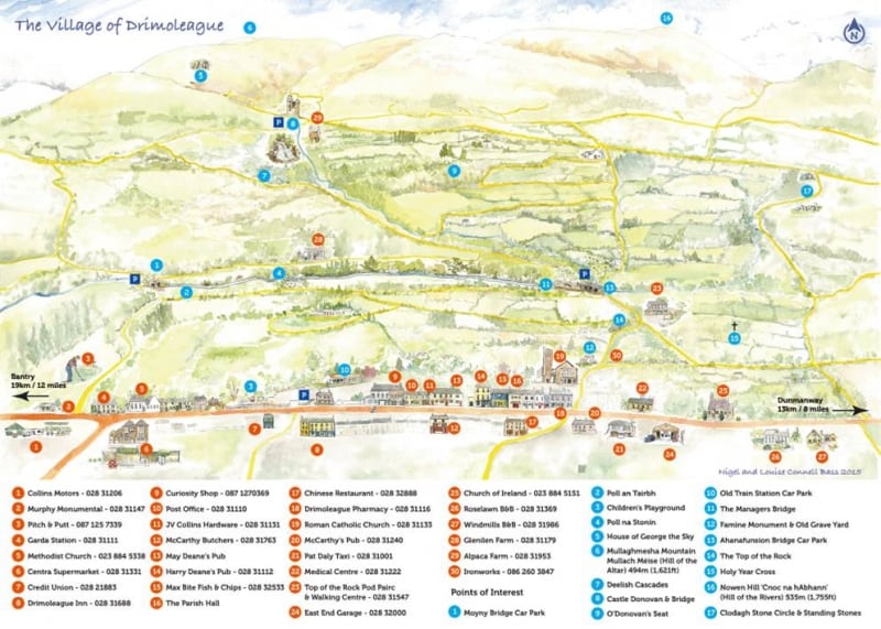
Brochure Design and Online Walks – Drimoleague Heritage Walkways
ActiveMe worked with David Ross of the Drimoleague Heritage Walkways Committee to design and develop their new high quality map Brochure to increase tourism and keep visitors in the area longer. This tourism group is made up of over 30 small rural local businesses located in and around the village of Drimoleague in West Cork. ActiveMe worked closely and consulted with the group at all stages to develop their map layout and design, a doubled sided full colour A3 to DL folding brochure which illustrated all 10 Drimoleague walk on a clear map in addition to the locations of all local businesses and points of interest.
In addition to the Brochure design for Top of the Rock, the Drimoleague Heritage Walkways Committee commissioned ActiveMe to GPS survey and digitise 12 walking routes for the ActiveMe Travel Guide along with links back to their own websites and booking pages for maximum exposure to the over 250,000 annual users on ActiveMe website and Free Apps.
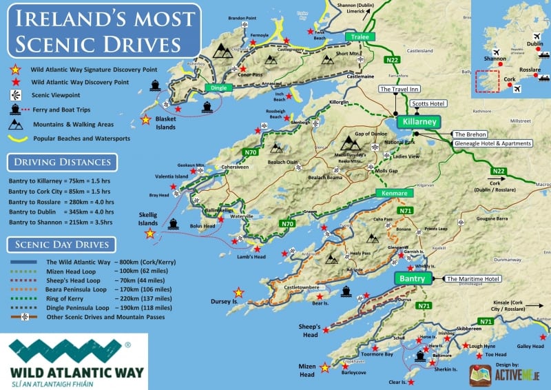
West Cork Scenic Drives Map Design – Maritime Hotel Bantry
ActiveME designed a scenic driving route map for the West Cork and Kerry region along the Wild Atlantic Way for the Maritime Hotel in Bantry.
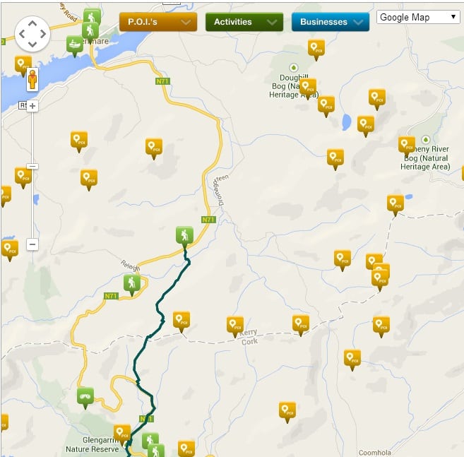
Training: Location Aware Tourism Content and Geocoding
Location Aware Tourism information (Geocoded), online maps and smartphone GPS are changing the way we travel, explore the outdoors, use maps and promote tourism. With this in mind, ActiveMe provides specific Geocoding training to local tourism businesses and tourism groups to make sure that all relevant marketing material such as businesses, places to see, things to do, points of interest, walks, cycles, photographs and more are geotagged and made ‘Location Aware’, that is suitable for use on any online map, App or during print design. Geocoding is the process of finding associated geographic coordinates (often expressed as latitude and longitude). With geographic coordinates, all information can be mapped and used for online maps, or the coordinates added to various media such as digital photographs via geotagging.
Once geocoded, the tourist information for a destination can easily be added to the ActiveMe Travel Guide website and apps, Google Maps or any other mapping based system to make it easier for tourists to find your business and the things to see and do in the area.
ActiveMe provided this training to the Bonane Tourism Group consisting of up to 40 local businesses.
Story Photo Design for ActiveMe, Killarney Walking Festival and Others
Design of ‘Suggested Tourist Itineraries’ – ActiveME, Skellig Coast Tourism Group and Others
ActiveMe will research, review and collect all available tourist information, things to see and do (both well known and hidden gems) and local businesses to create unique half day to 2 week plus itineraries to help tourists plan their holiday and to encourage additional bed nights and tourist spend when they arrive. These are created using high quality local information, photographs and accurate mapping.
These suggested itineraries are designed by ActiveMe to grab the tourists attention when are planning their holidays online and also after they arrive in Ireland. Commissioning ActiveME to collect this information and create unique itineraries also allows tourism businesses and groups to avail to adding this information to the ActiveMe Travel Guide and therefore tapping into over 250,000 annual users on the ActiveMe website and free Apps for maximum exposure of your destination and business.
ActiveMe – Suggested Itineraries – Half Day Killarney Trip – Full Day Killarney Trip
Family Tree and Genealogy
With our in-house qualified Genealogist Deirdre McCarthy, ActiveMe can offer you both genealogy research and family tree design services. Below is a sample of our Family Tree design which goes back as far as the 1700’s with Pirate Ancestry. This Family was printed and framed to A0 size and is very impressive and easy to understand with photographs displayed for family members when available.

Glendalough Heritage Project – Transcription of Audio Interviews
ActiveME provided transcription services for over 10 hour of oral history interviews for the Glens of Lead Project, an initiative of The Glendalough Mining Heritage Project (GMHP), Wicklow. Approximately 10 hours of the interview footage are proposed for transcription as part of this tender. ActiveMe produced a summary and a transcription of each oral history recording, with detailed formats, formulas and standard adhered to. ActiveMe created an accurate and consistent transcript of the interviews, an informative transcription abstract and a detailed summary with audio times and tag word to allow for easy location of specific information at any time in the future.
Based on experience and professional industry standards, 1 hour of audio/footage equates to approximately 6.5 hours review/typing/editing for a full transcript to international heritage standards, an abstract summary and a detailed Interview Summary with timings, tag words and full transcript page number.
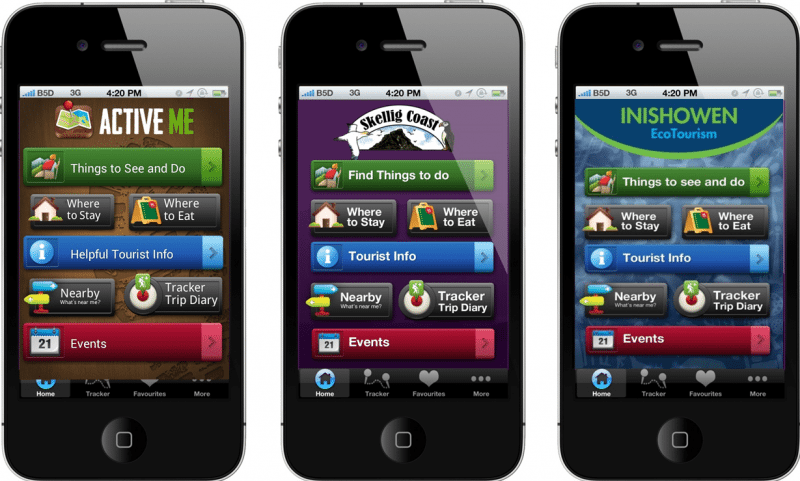
Tourism Smartphone Apps
Using the ActiveMe App template, we have developed a number of tourism based smartphone Apps in Ireland for local business groups, the details of which can be seen here on our Tourism App Page.
Digital Tourism Content Collection and Destination Marketing
